Chatyr-Dag
| Chatyr-Dag / Çatır Dağ | ||
|---|---|---|
|
Chatyr-Dag |
||
| height | 1527 m | |
| location | Crimea | |
| Mountains | Crimean Mountains | |
| Coordinates | 44 ° 44 ′ 0 ″ N , 34 ° 18 ′ 0 ″ E | |
|
|
||
|
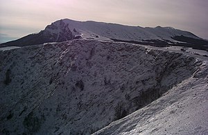
Southern plateau in winter |
||
Chatyr-Dag ( Crimean Tatar Çatır Dağ , Ukrainian Чатир-Даг , Russian Чатыр-Даг ) is a mountain range on the Crimean peninsula . In the language of the Crimean Tatars , “çatır” means “tent”, “dağ” means “mountain”.
construction
The massif consists of a northern and southern high plateau, the northern plateau being lower. This is covered with steppe grass, whereas the higher plateau in the south is covered by beech and juniper . A large number of hiking trails extend over the entire mountain, and the massif is lined with some cave systems. At the eastern end of the lower plateau there are also yew groves .
The southern plateau has a concave shape - the peaks on the edge of the plateau are all named, with the Eklizi-Bourun being the highest peak at 1527 meters above sea level. The slopes are partly very steep and are therefore well suited for rock climbing .


