Tschirka-Kem
|
Tschirka-Kem Чирка-Кемь, Чирко-Кемь, Tširkkakemijoki |
||
|
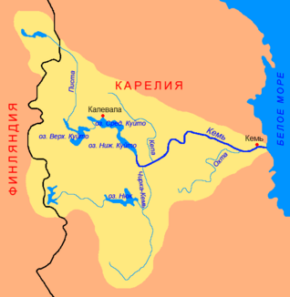
Tschirka-Kem in the catchment area of the Kem |
||
| Data | ||
| Water code | RU : 02020000912102000003648 | |
| location | Republic of Karelia (Russia) | |
| River system | Kem | |
| Drain over | Kem → White Sea | |
| source |
West Karelian ridge 63 ° 38 ′ 7 ″ N , 31 ° 50 ′ 26 ″ E |
|
| muzzle | in the lake Yashkoyarvi coordinates: 64 ° 45 ′ 29 ″ N , 32 ° 7 ′ 0 ″ E 64 ° 45 ′ 29 ″ N , 32 ° 7 ′ 0 ″ E
|
|
| length | 221 km | |
| Catchment area | 8270 km² | |
| Discharge at the Andronova Gora A Eo gauge : 2730 km² Location: 97 km above the mouth |
MNQ 1932/1988 MQ 1932/1988 Mq 1932/1988 MHQ 1932/1988 |
11 m³ / s 29 m³ / s 10.6 l / (s km²) 71 m³ / s |
| Discharge at the Juschkosero A Eo gauge : 8220 km² Location: 6 km above the mouth |
MNQ 1955/1988 MQ 1955/1988 Mq 1955/1988 MHQ 1955/1988 |
31 m³ / s 81 m³ / s 9.9 l / (s km²) 168 m³ / s |
| Left tributaries | Rastas , Chjame | |
Tschirka-Kem ( Russian Чирка-Кемь, Чирко-Кемь , Finnish Tširkkakemijoki ) is a right tributary of the Kem in the Republic of Karelia in northwestern Russia .
The river has a length of 221 km and a catchment area of 8,270 km². It rises on the West Karelian ridge . From there it flows in a predominantly northerly direction and flows into Lake Yashkojarwi (Яшкоярви) through which the Kem flows . At its mouth, the Tschirka-Kem reaches an average discharge of 81 m³ / s. The two left tributaries, Rastas and Chjame, drain Lake Nyuk to the west to Tschirka -Kem.
Individual evidence
- ↑ a b Tschirka-Kem in the State Water Directory of the Russian Federation (Russian)
- ↑ a b c Article Tschirka-Kem in the Great Soviet Encyclopedia (BSE) , 3rd edition 1969–1978 (Russian)
- ↑ Tschirka-Kem at the Andronova Gora gauge - hydrographic data at R-ArcticNET
- ↑ Tschirka-Kem at the Juschkosero gauge - hydrographic data at R-ArcticNET
