
Tsomgo lake
| Tsomgo lake | ||
|---|---|---|

|
||
| Geographical location | East Sikkim ( India ) | |
| Drain | → Rangpo Chhu → Tista | |
| Data | ||
| Coordinates | 27 ° 22 '31 " N , 88 ° 45' 50" E | |
|
||
| Altitude above sea level | 3780 m | |
| surface | 23.6 ha | |
| Middle deep | 15 m | |

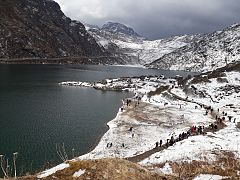
The Lake Tsomgo (also Tsongmo Lake or Changu Lake ) is a glacial lake in the eastern Himalayas in East Sikkim ( India ).
The mountain lake is located 15 km east of the capital Gangtok at an altitude of 3780 m . It has a water surface of 23.6 hectares and a circumference of 2 km. The oval-shaped lake is almost a kilometer long and has an average depth of 15 m. The lake is located in the catchment area of the Rangpo Chhu , a left tributary of the Tista . Tsomgo Lake is accessible from Gangtok via a 40 km long road that continues to the Nathu La border pass . It is considered a "holy lake" and is a tourist destination in Sikkim. Due to the proximity to the Chinese border, special authorizations are required.

Tsomgo Lake (January 2014)


Tsomgo Lake: April 2017

In frosty temperatures

Sikkim


Web links
- Navigator India: Tsomgo Lake - Permit, regutations & weather. In: northeast-india.in. Retrieved June 10, 2020 .