Rangpo Chhu
| Rangpo Chhu | ||
|
Rangpo Chhu above its confluence with the Tista; on the right bank of the river the city of Rangpo |
||
| Data | ||
| location | East Sikkim , West Bengal ( India ) | |
| River system | Brahmaputra | |
| Drain over | Tista → Brahmaputra → Indian Ocean | |
| Headwaters | at Jelepla Pass 27 ° 22 '21 " N , 88 ° 51' 38" E |
|
| Source height | approx. 4250 m | |
| muzzle |
Tista coordinates: 27 ° 10 ′ 21 ″ N , 88 ° 31 ′ 17 ″ E 27 ° 10 ′ 21 ″ N , 88 ° 31 ′ 17 ″ E |
|
| Mouth height | approx. 300 m | |
| Height difference | approx. 3950 m | |
| Bottom slope | approx. 88 ‰ | |
| length | approx. 45 km | |
| Catchment area | approx. 550 km² | |
| Left tributaries | Rongli Chhu , Rishi Khola | |
| Flowing lakes | Menmecho Lake | |
| Reservoirs flowed through | Rangpo Reservoir | |
| Small towns | Rangpo | |
|
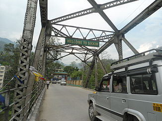
Rangpo Bridge at Rangpo |
||
The Rangpo Chhu (or Rangpo Chu ) is a left tributary of the Tista in the East Sikkim district , the eastern part of the Indian state of Sikkim , and on the border with West Bengal .
The Rangpo Chhu has its headwaters northwest of the Jelepla Pass . It initially flows in a south-westerly direction. It flows through the small mountain lake Menmecho-See . Later he picks up the outflow of Lake Tsomgo from the right and then turns south. The river is dammed by the Rangpo Dam , where the majority of its river water is fed through a tunnel and pressure pipe system to the hydroelectric power station located 6 km downstream. There the Rongli Chhu joins the Rangpo Chhu from the left. The Rangpo Chhu now flows in a westerly direction. Below the confluence of the Rishi Khola from the left, the river forms the border to the Indian state of West Bengal in the south. The Rangpo Chhu finally flows into the Tista near the small town of Rangpo . There the National Highway 31A crosses the river. The Rangpo Chhu has a length of approx. 45 km. Its catchment area covers 550 km².
Hydropower
At Rangpo Chhu there are two hydropower projects that are being built and operated by Gati Infrastructure .
The Chuzachen hydroelectric power station ( ⊙ ) is located directly above the confluence of the Rongli Chhu. It has two vertical Francis turbines from Alstom of 55 MW each and 2 generators of 49.5 MW each. It was built in 2007-2013. The power plant is supplied with water by two dams, the Rangpo Dam ( ⊙ ) and the Rongli Dam . The pressure tunnels of both dams unite halfway. On April 16, 2009, an accident occurred in which twelve workers were killed in the tunnel system.
The planned Bhasmey hydropower plant is to be built 6 km above the estuary. Two Francis turbines of 27 MW each are planned. A pressure pipe is to lead to the power plant from the dam planned for 5 km upstream. The nominal flow rate is 55 m³ / s.
Web links
Individual evidence
- ^ Gati Infrastructure
- ↑ power-technology.com: Chuzachen Hydroelectric Power Project, Sikkim, India
- ↑ a b South Asia Network on Dams, Rivers and People www.sandrp.in: Rangpo Dam Collapses ( page no longer available , search in web archives ) Info: The link was automatically marked as defective. Please check the link according to the instructions and then remove this notice.
- ↑ a b Lahmeyer: Bhasmey HEP (54 MW) Sikkim, India ( Memento of the original from March 4, 2016 in the Internet Archive ) Info: The archive link was automatically inserted and not yet checked. Please check the original and archive link according to the instructions and then remove this notice.
- ↑ Gati Infrastructure Bhasmey Power Pvt Ltd.

