Tumiloto
| Tumiloto | ||
|---|---|---|
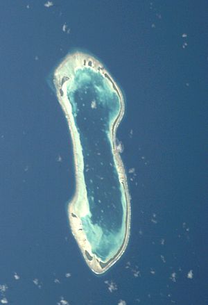
| Satellite image of the Nukulaelae Atoll with Tumiloto at the top right. | ||
| Waters | Pacific Ocean | |
| Archipelago | Nukulaelae | |
| Geographical location | 9 ° 22 ′ S , 179 ° 50 ′ E | |
|
|
||
Tumiloto is a reef island in the reef rim of the Nukulaelae Atoll in the island state of Tuvalu .
geography
Tumiloto, together with Niuoko and some tiny islets, forms the eastern edge of the reef of the atoll. The island is very elongated and slightly S-shaped from north to south-east. It is only separated from Kalilaia and Tapulaeani in the south by narrow channels. In the north, Motukatuli joins to the west . The island is planted with coconut trees.
Individual evidence
- ↑ Map of Nukulaelae Atoll. Tuvaluislands.com.
- ^ British Admiralty Nautical Chart 766 Ellice Islands. 21 March 1872, United Kingdom Hydrographic Office (UKHO) 1893.
- ↑ geonames.org .
- ↑ geoview.info .

