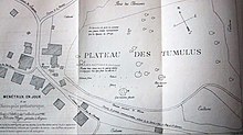
Menétrux-en-Joux tumuli
The tumuli of Menétrux-en-Joux , in the department of Jura in the region Bourgogne Franche-Comté in France , were discovered by Louis Abel Girardot (1848-1937) in the year 1887th In contrast to those of Combe d'Ain, these tumuli were raised over cremation graves. Many burial mounds in the Jura region were examined in the 19th century.
The Menétrux-en-Joux group of hills lies on a small rock plateau above the village of Menétrux-en-Joux . Two of the 40 mounds of a once larger necropolis have been excavated. The first, on the western edge of the plateau, has a diameter of 12 m and a height of 1.6 m. It was a multilayer burial mound that contained traces of charcoal and ash. The second hill was smaller and more common on the burial ground.
According to the study by Félicien Paget, the hills date from the Celtic or Iron Age .
Web links
- Description ( Memento from April 2, 2015 in the Internet Archive )
Coordinates: 46 ° 37 ′ 22.7 " N , 5 ° 49 ′ 51" E

