
Tower of Akkum
Coordinates: 36 ° 28 '20.3 " N , 34 ° 6' 58" E


The tower of Akkum is an ancient watchtower in the rough Cilicia .
location
The tower is in the Silifke district of the Turkish province of Mersin . It is located about 2.5 kilometers northwest of Kızkalesi , the ancient Korykos , and 20 kilometers northeast of the district town of Silifke on the west side of the Şeytan Deresi valley , which stretches from Kızkalesi to the north-west into the mountainous interior to Uzuncaburç , the ancient Olba . It belongs to the territory of the Hellenistic priestly state of Olba. The towers of Gömeç and Sarayın are about three and four kilometers northeast, respectively, and 2.5 kilometers southwest of Boyan , which together with the tower of Yalama formed a series of watchtowers that had visual contact with one another.
description
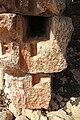
The tower has a floor plan of 5.15 × 4.60 meters, is oriented to the southwest and built in isodomic masonry, which means that all the stones have approximately the same cuboid format. It has a ground floor, two upper floors and an open combat platform above, which is largely surrounded by well-preserved battlements . The beams supporting the floors lay on brackets on the north-south walls and on simple steps on the east-west walls. The first floor has small slotted windows on all sides, on the second there are windows on all sides and two side by side to the east. Since the original floor level has been preserved, the height of the door can be given as 1.92 meters. Holes for locking bars can be seen inside the door. Above the south-west facing door there is a machicolation at the height of the window . A drainage spout for the platform is installed on the east wall and on the north side for the third floor. The wet rooms on the first floor were drained via a canal system in the east wall, as can also be seen in Sarayın. On the outside of the lintel there are two Olbic characters in relief, a club and a wreath, which indicate that the building belongs to the Olbic domain.
In the vicinity of the tower, the remains of farm buildings and an oil press can be seen, which indicates that the square had an agricultural function at the same time.
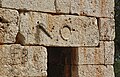
Lintel with olbic characters

East side with water drain on the first floor

North and east sides with gargoyles

East and south sides inside
Door frame with locking devices


Towers in the rough Cilicia
In the Rough Cilicia, especially in the area between the rivers Kalykadnos, today Göksu , and Lamos, today Limonlu , there are numerous towers from the late Hellenistic period to the Roman Empire . Partly free-standing, partly built into settlements and fortifications, the function as a watchtower is common to all. They were used to defend against attacks, mainly by pirates who settled here after the rule of the area in the 2nd century BC. Passed from the Seleucids to the Romans . Five free-standing towers (Akkum, Boyan, Gömeç, Sarayın and Yalama) with ashlar masonry are grouped around Korykos and Elaiussa Sebaste, which took turns as the metropolis of the region around the turn of the millennium . They also have a living and storage function. Food such as grain could be stored in the lower, lightless floors, and they also served as a retreat for the residents of the surrounding area. Archers could defend them from the top, crenellated platforms. Due to the similar design and the fact that they were three to five kilometers apart, they can be viewed as a group that belongs together with a watchful and signaling character. Their probable time of origin is limited by the end of the Seleucid rule in 133 BC. BC, the defeat of the pirates in 65 BC. By Pompey and the latest date in AD 74 when the area became a Roman province.
literature
- Serra Durugönül : towers and settlements in the Rough Cilicia. Asia Minor Studies Volume 28. Rudolf Habelt, Bonn 1998 ISBN 3-7749-2840-1 pp. 76-77, 92, 122.