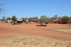
Tutume (Botswana)
| Tutume | ||
|---|---|---|
|
|
||
| Coordinates | 20 ° 30 ′ S , 27 ° 2 ′ E | |
| Basic data | ||
| Country | Botswana | |
| Central District | ||
| ISO 3166-2 | BW-CE | |
| height | 1105 m | |
| Residents | 17,528 (2011) | |
Tutume is a place in the Central District in Botswana . It is the seat of the sub-district of the same name .
geography
In 2011 Tutume had 17,528 inhabitants. The place is named after the river of the same name , where Tutume lies and which flows into the Nata in the west .
Tutume is located in the northeast of the country, about 100 kilometers northwest of Francistown . It is about 40 kilometers to the Zimbabwean border .
Most of the residents are Bakalanga.
The average temperature is 20.1 ° C, the annual mean rainfall 448 millimeters.
history
In 1981 the population was 3736. Since then the place has grown rapidly.
Economy and Infrastructure
Agriculture is predominant. Local roads connect Tutume to the trunk road network and to the Zimbabwean border.
Tutume has a hospital and - among other schools - a senior secondary school.
Personalities
- Isaac Makwala (* 1986), athlete, born in Tutume
See also
Individual evidence
- ↑ Information on the sub-district at yellowpages.bw (English), accessed on September 4, 2016
- ↑ 2011 Census Report, PDF page 170. ( Memento from June 2, 2015 in the Internet Archive ) (English; PDF; 4.35 MB)
- ^ Jan Hesselberg: The third world in transition: case of the peasantry in Botswana. Nordic Africa Institute, Uppsala 1985, ISBN 9171062432 , p. 128. Excerpts from books.google.de
- ↑ Climate data at en.climate-data.org (English), accessed on September 5, 2016

