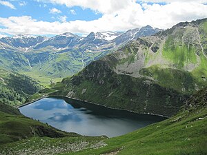
Lower Bockhartsee
| Lower Bockhartsee | ||
|---|---|---|

|
||
| Lower Bockhartsee against Nassfeld | ||
| Geographical location | Pongau , State of Salzburg , Austria | |
| Tributaries | from the Upper Bockhartsee | |
| Drain | to the Nassfelder Ache | |
| Data | ||
| Coordinates | 47 ° 4 '34 " N , 13 ° 3' 20" E | |
|
|
||
| Altitude above sea level | 1872 m above sea level A. | |
| length | 1.18 km | |
The lower Bockhartsee lies at 1872 m above sea level. A. in Bockharttal in southern Pongau . It is an artificially created reservoir that belongs to the former Bockhart area, where gold was mined until the middle of the 20th century.
history
Karl Imhof , Director of the Second Radhausberg Union , planned a deep exploration program in gold mining. This provided for a modern mining operation with appropriate technical facilities. A sufficient supply of energy was essential for this. In Böckstein there was already a small power station with 37 HP output, but it was insufficient for the planned expansion of the mining facilities. For this reason, two small hydropower plants were built in 1912 and 1913 in the area of the Upper Bockhartsee and Lower Bockhartsee. Karl Imhof's project included the construction of a water intake on the Lower Bockhartsee and a power station in Nassfeld . The process water required for this (106 liters per second) was directed through a 1550 meter long and 30 cm thick cast iron pipe through alpine terrain into the Nassfeld. In the area of the lake drainage, an outlet about two meters deep and 1.2 meters wide was created by blasting and a pipeline was installed. Despite the construction of this pipeline, the power station in Nassfeld temporarily had too little service water. Therefore the expansion of the compensation basin Unterer Bockhartsee was necessary. The dam was raised. The crown length of the dam was 39.6 m with a maximum height of 5.5 m. The original water intake was replaced by a pressure tunnel. The renovation made it possible to store 704,000 cubic meters more of water. In the course of the construction work for the Pochkar underground tunnel between the two lakes, the Pochkar power plant was built to operate the technical systems .
In 2007, new work was completed on the Lower Bockhartsee. In the course of the construction work, the dam was raised by a further eight meters.
Name story
In the heyday of gold mining in this region, in the Middle Ages , the name Pochkarsee was created . However, this name changed in the course of time to Pockhart , Bockhardt and finally to today's common name Bockhartsee.
literature
- Cech, Brigitte : Archaeological research on the extraction of precious metals in the 15th and 16th centuries in the Gastein Valley , in: Communications from the Society for Salzburg Regional Studies , 141st year of association 2001, Salzburg 2001
- "Treasure Chamber Hohe Tauern", 2000 years of gold mining , ed. Wilhelm Günther and Werner H. Paar , with contributions by Fritz Gruber and Volker Höck , Verlag Anton Pustet , Salzburg
Individual evidence
- ↑ Austrian Map online
- ↑ measured in Austrian Map online
- ↑ Source www.fischerverein-gastein.at/chronik.html ( Memento of the original from February 4, 2011 in the Internet Archive ) Info: The archive link was inserted automatically and has not yet been checked. Please check the original and archive link according to the instructions and then remove this notice.
Web links
- Lower Bockhartsee in the Salzburgwiki
