Upshi
| Upshi | ||
|---|---|---|
|
|
||
| State : |
|
|
| Union Territory : | Ladakh | |
| District : | Leh | |
| Location : | 33 ° 50 ′ N , 77 ° 49 ′ E | |
| Height : | 3407 m | |
| Residents : | 163 (2014) | |
| Upshi | ||
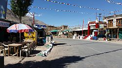
Upshi is a place in the Indian union territory of Ladakh .
Location and inhabitants
The place is 49 km southeast of Leh on the Manali-Leh Highway near the Hemis National Park , on the Indus . In Upshi the road divides along the Indus towards the Chinese border through the Changthang to Chushul and further south towards Gya and Manali. Driving through the Ladakhi Changthang in the direction of Tibet is not permitted for non-Indian tourists.
In 2014, 128 people lived in the place. The inhabitants live mainly from agriculture, especially goat husbandry is widespread. The area around Upshi is mountainous and practically uninhabited. There are no other settlements in the vicinity.
climate
The climate in Upshi is known as the steppe climate. There is comparatively little rainfall over a year. The classification of the climate by Köppen and Geiger is BSk . An annual average temperature of 6 ° C is reached in Upshi. The coldest month of January reaches an average of 24.9 ° C less than the warmest month of July.
The average annual rainfall is 174 mm. In June there is on average the least rainfall. When compared to the wettest month, March, the difference is 20 mm.
| Upshi | ||||||||||||||||||||||||||||||||||||||||||||||||
|---|---|---|---|---|---|---|---|---|---|---|---|---|---|---|---|---|---|---|---|---|---|---|---|---|---|---|---|---|---|---|---|---|---|---|---|---|---|---|---|---|---|---|---|---|---|---|---|---|
| Climate diagram | ||||||||||||||||||||||||||||||||||||||||||||||||
| ||||||||||||||||||||||||||||||||||||||||||||||||
|
Average monthly temperatures and rainfall for Upshi
Source: Climate Data
|
||||||||||||||||||||||||||||||||||||||||||||||||||||||||||||||||||||||||||||||||||||||||||

