
Vífilsstaðavatn
| Vífilsstaðavatn | ||
|---|---|---|
| Geographical location | Iceland | |
| Drain | Hraunholtslækur | |
| Location close to the shore | Garðabær | |
| Data | ||
| Coordinates | 64 ° 4 ′ 45 ″ N , 21 ° 52 ′ 19 ″ W | |
|
||
| Altitude above sea level | 38 m | |
| surface | 30 ha | |
| Maximum depth | 1.7 m | |
| Middle deep | 0.5 m | |

The Vífilsstaðavatn is a small lake near the village of Garðabær in the capital region of Iceland .
It has been under nature protection since 2007 as part of a resource protection area totaling 188.25349 hectares . There is a 2.5 km long paved path along the shore.
Picture gallery

Vífilsstaðavatn (2010)
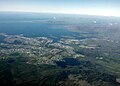
Aerial view from Vífilsstaðavatn (bottom left, 2011)
.jpg)

Web link
Vífilsstaðavatn on Youtube , accessed October 20, 2016
Individual evidence
- ↑ Running in Iceland , accessed October 21, 2016