Garðabær

|
|
| Basic data | |
|---|---|
| State : |
|
| Region: | Höfuðborgarsvæðið |
| Constituency : | Suðvesturkjördæmi |
| Sýsla : | circular |
| Population: | 16,299 (January 1, 2019) |
| Surface: | 71 km² |
| Population density: | 229.56 inhabitants / km² |
| Post Code: | 210, 212 |
| politics | |
| Community number | 1300 |
| Mayor: | Gunnar Einarsson |
| Contact | |
| Address of the municipal administration: | Garðatorgi 7 210 Garðabær |
| map | |

Coordinates: 64 ° 5 ′ N , 21 ° 54 ′ W |
|
Garðabær [ 'karðaˌpaiːr ̥ ] ( dt. Wallhöft ) is a town in southwest Iceland in the densely populated region Höfuðborgarsvæðið between Hafnarfjörður and Kópavogur south of Reykjavík . With 16,299 inhabitants (as of January 1, 2019) it is the fifth largest city and sixth largest municipality in the country.
history
Garðabær, like Hafnarfjörður further south, was built on the lava of Búrfell , which erupted around 7,200 years ago .
In Landnámabók , in the area of today's Garðabær with the homesteads Vífilsstaðir and Skúlastaðir, settlements are mentioned that already existed at the time of the conquest . Vífilsstaðir was the court of Vífill , a slave of Ingólfur Arnarsons , the first settler on the island. Up until the 1960s, Garðabær was more of a rural character. Due to the increased emigration from the sparsely populated regions of the island and the resulting concentration of the total population in the capital region around Reykjavík, the population of Garðabær also increased (1960: 1000, 1976: more than 4000 inhabitants), whose outskirts now to the surrounding cities adjoin. In 1976 the place received market rights and got city status . Garðabær is essentially a city characterized by modern, purpose-oriented architecture; the predominantly loose development of the housing estates is striking. In early 2013 , Álftanes merged with Garðabær.
Culture and sights
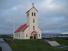
The core city itself offers hardly any sights. However, the Icelandic Museum of Design and Applied Arts, founded in 1998, and the two architecturally modern and simple church buildings, including the white concrete church Vídalínskirkja built in 1995 and the older Garðakirkja as well as the town hall tower, which can be seen from afar, deserve special mention . In addition, in the district of Álftanes there is the presidential residence Bessastaðir and Bessastaðakirkja , one of the oldest church buildings in Iceland.
economy
Garðabær is the seat of the companies 66 ° North and Marel .
traffic
The city is connected to the Hringvegur , Iceland's most important artery, via road 41 . Keflavík Airport is to the southwest .
Sports
The UMF Stjarnan association comes from Garðabær .
Town twinning
Garðabær has partnerships with
-
 Asker , Norway
 -
 Rudersdal Municipality , Denmark
 -
 Eslöv , Sweden
 -
 Jakobstad , Finland
Sons and daughters
- Ólafur Jóhann Sigurðsson (1918–1988), writer
- Sigurður Bjarnason (* 1970), handball player and coach
- Garðar Jóhannsson (* 1980), football player
- Gunnhildur Yrsa Jónsdóttir (* 1988), soccer player
See also
Web links
- City administration website (Icelandic, English)
Individual evidence
- ↑ cf. Archive link ( Memento of the original from October 26, 2012 in the Internet Archive ) Info: The archive link was automatically inserted and not yet checked. Please check the original and archive link according to the instructions and then remove this notice. (English); Accessed October 23, 2012
- ↑ cf. http://www.gardabaer.is/?PageID=139 Homepage of the municipality on the town twinning (Icelandic); Accessed August 13, 2011

