Seltjarnarnes

|
|
| Basic data | |
|---|---|
| State : |
|
| Region: | Höfuðborgarsvæðið |
| Constituency : | Suðvesturkjördæmi |
| Sýsla : | circular |
| Population: | 4664 (January 1, 2019) |
| Surface: | 2.3 km² |
| Population density: | 2,027.83 inhabitants / km² |
| Post Code: | 170, 172 |
| politics | |
| Community number | 1100 |
| Mayor: | Jónmundur Guðmarsson (since 2002) |
| Contact | |
| Address of the municipal administration: | Austurström 2, 170 Seltjarnarnes |
| Website: | www.seltjarnarnes.is |
| map | |

Coordinates: 64 ° 9 ′ N , 22 ° 0 ′ W |
|
The municipality of Seltjarnarnes ([ 'sɛːlˌtjartnarˌnɛˑs ], isl. Seltjarnarnesbær ) is located in the capital region ( Höfuðborgarsvæðið ) of the Icelandic capital Reykjavík .
On January 1, 2019, the community had 4664 inhabitants. The area of the municipality is 2 km². Contrary to the general trend in the capital region, Seltjarnarnes has seen a noticeable decline in population for several years.
location
Seltjarnarnes is located on the peninsula of the same name and is surrounded in the north, west and south by Faxaflói (in the south by its branch Skerjafjörður and in the north by Kollafjörður ). In the east the municipality borders on the Vesturbær district of the capital Reykjavík and is structurally connected to it. The city limits run through residential areas.
Despite its proximity to Reykjavík, the city has its own geothermal heating.
history
In 1974 the rural community Seltjarnarneshreppur received city rights.
Attractions
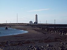
Grótta , a small (half) island in the west of Seltjarnarnes, which can only be reached at low tide. On it stands the lighthouse, which can be seen from afar, and a popular northern light hot spot.
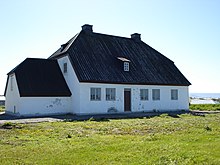
The Nesstofa Medical Museum is located on the western edge of the town. The building dates from 1761 to 1763 and was built for the doctor Bjarni Pálsson . It served as a training center for doctors until 1876, when the medical college was founded.
The Pharmaceutical Museum (isl. Lyfjafræðisafn ) is right next to the Nesstofa. There is u. a. a pharmacy from the turn of the century is shown.

