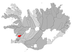
Kjós

|
|
| Basic data | |
|---|---|
| State : |
|
| Region: | Höfuðborgarsvæðið |
| Constituency : | Suðvesturkjördæmi |
| Sýsla : | Kjósarsýsla |
| Population: | 238 (January 1, 2019) |
| Surface: | 284 km² |
| Population density: | 0.84 inhabitants / km² |
| Post Code: | 276 |
| politics | |
| Community number | 1606 |
| Mayor: | Sigurbjörn Hjaltason |
| Contact | |
| Address of the municipal administration: | Ásgarði, 276 Kjós |
| Website: | www.kjos.is |
| map | |

Coordinates: 64 ° 21 ′ N , 21 ° 36 ′ W |
|
Kjós ( Isl. Kjósarhreppur ) is an Icelandic municipality in the Höfuðborgarsvæðið region in western Iceland .
On January 1, 2019, Kjós had 238 residents.
geography
At Kjós borders the capital city Reykjavíkurborg in the southwest and lies south of Hvalfjörður . In the northeast, the municipality borders on the municipality of Hvalfjarðarsveit and in the east on the municipality of Bláskógabyggð . In the far east is the mountain Botnssúlur , south of it the lakes Sandvatn and Myrkavatn , from which the Öxará flows.
Lake Meðafellsvatn is located relatively centrally in the municipality.
The Miðdalur , Eilífsdalur , Flekkudalur , Eyjadalur , Laxárdalur , Svínadalur , Fossárdalur and Brynjudalur valleys are located in the municipality .
Transport and infrastructure
The area is connected to the Hringvegur via the Hvalfjarðarvegur ![]() , which runs along the Hvalfjörður . The Kjósarskarðsvegur creates the connection to the Þingvallavegur from the northern part of the area to the south.
, which runs along the Hvalfjörður . The Kjósarskarðsvegur creates the connection to the Þingvallavegur from the northern part of the area to the south.
![]()
![]()