Very Long Baseline Interferometry
Very Long Baseline Interferometry ( VLBI ) or long base interferometry is a radio astronomy method for measurements with the highest spatial resolution and positional accuracy. It is used both for astronomical observations and for geodetic investigations in the field of earth measurements .
The spatial resolution of an interferometer is determined by the wavelength and the greatest distance between the antennas involved. In normal radio interferometers , the signals from the individual antennas are z. B. brought together via waveguides and brought to interference . Instead, the VLBI stores the signals from the individual antennas together with very precise time references and then correlates them mathematically. This makes it possible to receive interference over intercontinental distances or even with antennas in space (space VLBI).
astronomy
The exact position measurements of the VLBI are important for determining the astronomical coordinate system z. B. in the ICRF . The spatial resolution that can be achieved with VLBI is currently superior to that in other areas of the electromagnetic spectrum, but is limited to objects with bright radio emissions. With VLBI, the “jets” of high-energy particles emanating from the vicinity of black holes in active galactic nuclei are investigated. Further targets are, for example, maser sources in star formation regions , in the atmosphere of stars and again in the vicinity of active galactic nuclei.
In May 2012, VLBI was first used for a SETI project . The star Gliese 581 was researched with the instruments of the Australian Long Baseline Array .
Based on measurements from 2014 and 2015, a distance of more than 66,000 light years to a star formation area opposite the center of our Milky Way was determined by observing local maser sources using the trigonometric parallax distance measurement method .
geodesy

Geodesy is the science of measuring and mapping the earth's surface. Not only measuring devices and satellites are used, but also VLBI measurements for orientation on the earth's surface. Far-away celestial bodies, which appear point-like to us because of their great distance and which also seem to have no proper movement, are observed and used as a basis for determining positions on the earth's surface. This means that the distances between the radio telescopes are measured and their movements and directions of movement are determined with an accuracy of a few millimeters. This makes it possible to determine any deviations by comparing them with previous measurements.
Measuring principle
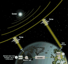
By precisely measuring the signals with two or more radio telescopes and storing them with time stamps , a type of transit time measurement is possible. The data are shifted on the time axis by means of a correlator until almost complete agreement of the signal peaks is achieved.
After this correlation, the shift corresponds to the transit time or path difference Δt 1,2 from the quasar to the two (or more) telescopes. By measuring several quasars (5–20 in an hour), a kind of surveying network is set up. Because the individual Δt are constantly changing due to the rotation of the earth , the current pole of rotation and the astronomical time can also be determined in addition to the coordinates .
The accuracy is around 0.1 ns (billionths of a second), converted to a distance of a few centimeters. Due to the large number of measurements (mostly automatic), meshes can be calculated to within ± 1 cm.
Data reduction and results
The measurements have to be corrected due to various influences:
- Refraction in the troposphere - dry and moisture content: the former is determined by air pressure and temperature , the latter is more difficult to model due to the strongly fluctuating content of water vapor
- Refraction in the ionosphere - it depends on the frequency of the radio waves and can therefore be approximated using two frequencies
- Time corrections
- Instrumental influences ( calibration of the antenna , eccentricity , etc.)
- Other influences
The results can be easily combined with other measurement methods - e.g. B. with GPS and its method of determining the second correction.
Through long-term determination of coordinates of radio telescopes , the movements of the can continents by plate tectonics be determined. For several years this has been possible with accuracies in the millimeter to centimeter range. The approximately ten large plates move against each other at 2 to 20 cm per year.
VLBI networks
The most important VLBI networks currently in use are:
- VLBA: Very Long Baseline Array (USA)
- EVN: European VLBI Network
- LBA: Long Baseline Array (Australia)
- VERA: VLBI Exploration of Radio Astrometry (Japan)
- IVS: International VLBI Service for Geodesy and Astrometry
- CVN: Chinese VLBI Network
- KVN: Korean VLBI Network (South Korea)
- EAVN: East Asian VLBI Network
- GMVA: Global mm-VLBI Array
- EHT: Event Horizon Telescope
See also
- Atacama Large Millimeter / submillimeter Array
- Very large array
- Mapping function
- RadioAstron
- GARS-O'Higgins
literature
- Franco Mantovani: The role of VLBI in astrophysics, astrometry and geodesy. Kluwer Academic, Dordrecht 2004, ISBN 1-4020-1875-4 .
- Fujinobu Takahashi: Very long baseline interferometer. Ohmsha, Tokyo 2000, ISBN 1-58603-076-0 .
Individual evidence
- ↑ No suspicious signal from Gliese 581 astronews.com
- ^ SETI Finds No Signs of ET Nearby ; H. Rampadarath, et al .: The First Very Long Baseline Interferometric SETI Experiment. @ Arxiv , accessed June 6, 2012
- ↑ Alberto Sanna, Mark J. Reid, Thomas M. Dame, Karl M. Menten, Andreas Brunthaler: Mapping Spiral Structure on the far side of the Milky Way in Science , issue of October 13, 2017
- ↑ An Overview of The LBA atnf.csiro.au
- ↑ About IVS ivscc.gsfc.nasa.gov, accessed June 6, 2012

