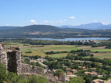
Valdaine
The Valdaine is a plain east of the central Rhône in the Drôme department . Since the city of Montélimar belongs to it, it is also called Bassin de Montélimar . The neighboring regions are the Valentinois in the north, the Diois in the east, the Tricastin in the south and the Bas- Vivarais in the west.
This basin forms an extensive amphitheater that opens to the west onto the alluvial terrace of Montélimar and the Rhône valley. In addition to the Rhône, the Valdaine is mainly drained by the Roubion and its tributary Jabron , which flow down from the Diois foothills of the Alps. It has an area of 300 square kilometers with a diameter of about 15 kilometers.
The name Valdaine is found in the place names Portes-en-Valdaine and Rochefort-en-Valdaine , both of which are on the southern edge of the plain. The commune of Saint-Geoire-en-Valdaine in the Isère department and in the west of the Chartreuse massif does not belong to the Valdaine, the name was derived from the Val d'Ainan.
literature
- Joël Vital, Archeology sur toute la ligne. Les fouilles du TGV Méditerranée dans la moyenne vallée du Rhône , Éd. Somogy-édition d'art et Musée de Valence, 2002, ( ISBN 285056513X )
Web link
- Cécile Jung, Le réseau viaire antique du Tricastin et de la Valdaine , RAN, 42, 2009, pp. 85–113 ( online )
