Velika planina
| Velika planina | ||
|---|---|---|
|
Planjava-Ojstrica group from Quantityš , on the left Velika planina |
||
| Highest peak | Gradišče (Nijvica) ( 1667 m. I. Y. ) | |
| location | Kamnik / Luče , Osrednjeslovenska / Savinjska , Slovenia | |
| part of | Steiner Alps / Kamniško-Savinjske Alpe | |
|
|
||
| Coordinates | 46 ° 18 '7 " N , 14 ° 39' 8" E | |
The Velika planina , German Großalm , is a mountain area on the southern edge of the Steiner Alps in Slovenia. It is a tourist center, and it is also part of the Kamnik municipality .
Location and landscape
The Velika planina located about 30 kilometers north of Ljubljana (Ljubljana) on the north edge of the Laibacher basin (Ljubljanske kotlina), above Kamnik (Stein in Krain), and 10 kilometers south west of Luče (Leutsch) at the uppermost Savinja (Sann).
The Kamniška Bistrica forms its western border . The southern border is the Črna valley , where the low hills of Gozd ( Vover 940 m ) lie against the Ljubljana basin. To the east, the Volovljek Pass ( 1029 m. I. J. ) connects the Volovljek brook and Brločnica , which flows over the Lučnica to the Savinja, with the mountains of the Veliki Rocatec ( 1557 m , Sanntaler hill country ). To the northeast, the Lučka Bela , another Lučnica source river, separates from the high plateau Dleskovška planota . To the north, the Velika planina merges into the eastern main ridge of the Steiner Alps with Planjava ( 2396 m ) and Ojstrica ( 2350 m ).
The highest point of the ridge is the Gradišče (Nijvica 1667 m. I. J. ), is expected in the broader sense the Dol (saddle 1321 m. I. J. ) north moreover, the Rzenik ( 1833 m. I. J. ), with the saddle Presedljaj ( 1614 mi J. ) as the northern border of the area.
The actual alpine region forms an independent village (Naselja) Velika Planina von Kamnik, the southeast part the village Žaga , the Planina Dol belongs to Kamniška Bistrica , the southern flank to Stahovica , Črna pri Kamniku , Potok v Črni , Podstudenec and Krivčevo , and the eastern roof to it Podvolovljek , a village in Luče.
History, culture and economy
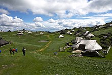
The plateau has been used by shepherds in transhumance since prehistoric times , traditionally from June to September. The shepherds' huts of Velika planina, called Preskarjeva bajta , are very characteristic . The oldest date from the 16th century. A windowless, clapboard, one-story wooden building with a central chimney rises on an oval floor plan. In the middle is the kitchen where cheese was made, and the individual bays for the cows are arranged in a circle around the kitchen. The shepherd's bed was above the kitchen. The Preskarjeva bajta is therefore a combination of alpine stables and a dairyman's hut, a typical south-east alpine Schwaige . The dried pear-shaped cheese Trniči is traditionally made on Velika planina .
In 1938 the Marije Snežne chapel was built according to the plans of the architect Jože Plečnik , which is formally similar to the shepherds' huts with its oval floor plan. In the winter of 1944/45, along with a large part of the shepherds' huts, it was destroyed by the German occupiers during the Second World War . It was rebuilt in 1988 on the initiative of the shepherds.
Since 1931 the tourist use of Velika planina began in the form of Bajtarstvo . These shepherds' huts were rented out in winter during the seasonal absence of the herds. Between 1959 and 1964, around 60 more huts were built away from the old shepherds' settlement designed by the Plečnik student Vlasto Kopač . On the outside, these huts look very similar to the Preskarjeva bajta of the shepherds, but the inside is very much tailored to the needs of tourists. Construction activities on Velika planina are now restricted by law to buildings of this type.
In the years 1963–1964 the Ljubljana Transport company built a cable car from the valley town of Stahovica to Velika planina. The hotel Šimnovec and the restaurant Zeleni rob were built in 1966. Shortly afterwards, ski lifts were built, so that Velika planina has since developed into a ski area.
Web links
- Website of the cable car operator (velikaplanina.si)
- To the Velika planina alpine pasture, slovenia.info


