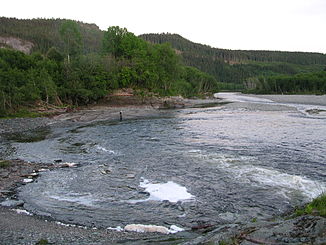
Verdalselva
| Verdalselva | ||
|
Verdalselva |
||
| Data | ||
| Water code | NO : 127.Z | |
| location | Trøndelag ( Norway ) | |
| River system | Verdalselva | |
| Drain over | Verdalselva → Atlantic Ocean | |
| confluence | from Helgåa and Inna 63 ° 46 ′ 36 ″ N , 11 ° 45 ′ 48 ″ E |
|
| Source height | 41 moh. | |
| muzzle | in the Trondheimsfjord coordinates: 63 ° 48 ′ 22 " N , 11 ° 25 ′ 57" E 63 ° 48 ′ 22 " N , 11 ° 25 ′ 57" E |
|
| Mouth height | 0 moh. | |
| Height difference | 41 m | |
| Bottom slope | 2 ‰ | |
| length | 21 km | |
| Catchment area | 1454 km² | |
| Small towns | Verdalsøra | |
The Verdalselva is a river in the Norwegian province of Trøndelag .
The river is created by the confluence of Helgåa and Inna near Vuku . From there it flows in a westerly direction and flows into the Trondheimsfjord at Verdalsøra .
The river has a length of 21 km and a catchment area of 1454 km².
