Villa (Illas)
| Municipality of Illas: Parroquia Villa | ||
|---|---|---|
| coat of arms | Map of Spain | |
 Help on coat of arms |
|
|
| Basic data | ||
| Autonomous Community : |
|
|
| Comarca : | Avilés | |
| Coordinates | 43 ° 31 ′ N , 5 ° 56 ′ W | |
| Height : | 62 msnm | |
| Area : | 5.9 km² | |
| Residents : | 181 (January 1, 2011) INE | |
| Population density : | 30.68 inhabitants / km² | |
| Postal code : | 33412 | |
| Area code: | 33030030000 | |
| Nearest airport : | Asturias Airport 14.5 km | |
| administration | ||
| Address of the municipal administration: | C / Callezuela nº1, 33411 - Illas | |
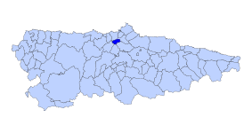
| Location of the municipality | ||

|
||
Villa is one of three parroquias and at the same time a place in the municipality of Illas in the autonomous region of Asturias in Spain .
geography
Villa has 181 inhabitants (2011) on an area of 5.60 km². It is 62 m above sea level. Illas, six kilometers away, is the next larger town and also the administrative seat of the municipality.
Villages and hamlets
- La Laguna 8 inhabitants 2011 43 ° 31 ′ 1 ″ N , 5 ° 57 ′ 25 ″ W
- Piniella 85 inhabitants 2011 43 ° 30 ′ 21 ″ N , 5 ° 56 ′ 4 ″ W
- Sanzadornin 88 inhabitants 2011 43 ° 30 ′ 23 ″ N , 5 ° 55 ′ 57 ″ W
Population development

|
| Source: website of the INE - graphical workup for Wikipedia |
Attractions
- Chapel of San Bartolomé or the Virgen de los Remedios
swell
- Population figures see INE
- For height information, see Google Earth
- Postcodes [1]
