
Villa Rustica (Zipfwang)


The Villa Rustica of Zipfwang was a Roman estate at Sulzberg in Oberallgäu which existed from the first century until at least the beginning of the third century.
Two of the buildings were already excavated by Ludwig Ohlenroth in 1936. A radar survey in 2013 identified the approximately 2 hectare complex as Villa rustica .
location
The Villa Rustica is located on a flood-free clay ridge between the hamlets of Unterhub and Zipfwang, about 50 meters away from a former backwater arm of the Iller (today "old Iller"). From the nearby ridge, three brooks strive towards the Iller, two of which were diverted in historical times and used to operate a mill ("Zipfelmühle").
The Roman city of Cambodunum is about 10 km as the crow flies, connected by the Iller . The Roman road Kempten Füssen is about 5 km away.
Results of the Ohlenroth excavation

Two buildings were explored. The building I located since the Middle Ages under a Kapellenbau, the Loja Chapel . The ancient building, measuring 5.4 by 14.7 meters, was initially erected in the 1st century as a timber structure with brick roofing and divided into three rooms. The dating could be secured by finds of period-typical ceramics and of clothes needles .
The building was expanded in stone in the first half of the 2nd century. A few decades later, one of the rooms was equipped with hypocaust underfloor heating. At the beginning of the 3rd century, the stone building was demolished and the southern part, now located under the chapel, was converted into a roughly square stone building with a small vestibule, which Ohlenroth interpreted as a temple, partially using the foundation walls. The external dimensions of this temple were about 6.80 by 6.40 meters, with a 75 cm wide vestibule. The interior had an area of about 22 m², so it was significantly larger than today's Loja Chapel. A 5-7 cm thick graveled piece of road was found running towards Building I from the north. Comparable temple buildings with small vestibules would be the "Temple C" of Pesch in the Eifel and small rectangular temples in the temple district of Cambodunum.
The Building II, in about 50 meters distance between one to three meter wide stream, was built in the 2nd century directly in stone. It initially had four rooms 2.90 wide, all of which could be heated by a hypocaust heater. The division and construction allows the allocation of the rooms in cold, warm and hot bath rooms and interpretation as a bath house. The access to the furnace in the south was protected by a wooden porch. Later a stone antechamber was added in front of the entrance, in which several layers of screed were preserved. In the vicus of Fort Pfünz there is a bath that corresponds to this building and is also fully heatable. A later extension over the entire length in the east added a 1.80 meter narrow and 11.50 meter long three-part interior, which is interpreted as a metal workshop due to the remains of iron slag. In the west, the area was about 3 meters wide, well paved with sandstone quarry slabs, and in a "heavily used" part it fell by 50 - 60 cm towards the watercourse. In the southern third of the west side, ditches were found for draining water and a timber extension used as a workshop.
Both buildings had glass window panes, remains of which were found.

Metal finds

One of the bronze robe pins certainly dates back to the 1st century (Hofheim type IIIa). The other three spread until the end of the 2nd century. An iron wood chisel shows wood processing, melt drops and a melting spoon bronze processing. Iron slag was found in and on both buildings. In building 1 there was a Roman key and a spoon made of iron.
Ceramic finds
The rich ceramic finds of all kinds could be dated from the first to the early 3rd century, often with comparative pieces from Cambodunum.
The local ceramics, such as cooking pots with a comb from the early 1st century, as well as various vessels made of Terra Nigra are of the Latène or Rhaetian style and show (as in Cambodunum) the continued existence of the local Celtic / Rhaetian indigenous population.
Various mortars from the 2nd century onwards show typical Roman kitchen traditions, for example the preparation of Moretum .
The luxury tableware Terra Sigillata dating from the 1st to the 2nd century was found many times in both buildings. It was first imported from southern Gaul and later from workshops in the Rhineland. A plate of the Belgian type and a Lavez vessel from the southern side of the Alps indicate extensive contacts.
Results of the 2013 radar survey

At least four other buildings have been identified, including a 20 by 20 meter main building with a central courtyard. It turns out that the excavated temple Ic is precisely aligned with the main house (today's Loja chapel above is slightly twisted). In addition, farm buildings, one of which shows evidence of an oven or workshop. In the surrounding area, large parts of the rounded, curved stone enclosure wall could be identified.
Within the wall there were several watercourses, one of which was an island of about 3 by 14 meters. Some buildings, including the bath, have connections to the waterways.
The current state of research is documented in the 2013 edition of The Archaeological Year in Bavaria .
The water supply of the manor
Ohlenroth interprets the name Loja as "the mouth of a small Ache", the pre-Roman name, into the Iller. This brook could have been the Huber Bach or the Albis- / Kenelsbach. The latter was diverted to the operation of the Zipfelmühle with the new name "Mühlbach". It has a catchment area of around 3 km², which results in an annual average of around 9 liters of water per second with a rainfall of 1274 mm.

This amount of flow results in an output of 16 HP per meter of gradient, which would make it possible to operate a water mill. Watermills are already documented in the Augustan era and were significantly improved in the middle of the 2nd century. In the 5th century, Palladius took it for granted that a larger estate should have a mill. During the excavation in 1936, a millstone about 60 cm in diameter was found.
During the first excavation, an oxbow river about 3 meters wide was found between the buildings, from south to north and with a strong curvature. The radar prospecting extended this to the south by a pond-like extension with an island. In addition, a 6-meter-wide oxbow river was recognized from the west, which suddenly ends within the settlement.
The end of Loja
Ohlenroth's excavation only yielded dating finds from the first to the third century, so there is no evidence of the continued existence of the estate after the imperial crisis of the third century , during which several times larger groups of Alemanni penetrated as far as Italy. At this time, around 260, the Limes wall and with it the Dekumatland was abandoned and the Limes was taken back on the DIRL ( Limesfall ). Cambodunum became a border town and moved from the Iller high bank to the Burghalde . The last remaining land border between the Rhine and the Danube ran from the Iller to Lake Constance via Isny .
But Loja still remained within the empire, 140 years until the legions withdrew (402) and another 134 years until the Allgäu was peacefully surrendered to the Franks.
The excavation of 1936 revealed that building II was destroyed by fire. Close by was a 50 cm thick layer of fire, which shows burned supplies (of wood) that were no longer cleared away. According to Ohlenroth, this would indicate that the area was no longer inhabited. In 1936, however, the dating options of the radiocarbon method and dendrochronology were not yet available to determine the time of this fire. The excavation of the main house now found should close the research gap.

View of the grounds of Villa Rustica with Loja Chapel in the evening sidelight

View of the grounds of Villa Rustica with the Loja chapel and the backwater of the Iller
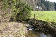
Kenelsbach at the point of the modern diversion to the Zipfelmühle

Loja area seen from the Kenelsbach. In the background Alte Iller and Iller


literature
- L. Ohlenroth: The Roman settlement at the Loja chapel . In: Allgäu history friend . tape 41 , 1937, ISSN 0178-6199 , DNB 011812389 , p. 51 to 73 .
- Roland Linck, Jörg WE Faßbinder , Léa Front, Florian Becker: Ground radar prospection enables reconstruction of the Roman villa at the Loja Chapel in Sulzberg . In: The Archaeological Year in Bavaria . 2013, ISBN 978-3-8062-3008-6 , pp. 103 to 105 (from academia.edu [accessed January 25, 2015]).
Web links
- Villae rusticae in the province of Raetia - online documentation of the RGZM (Roman-Germanic Central Museum)
- The preparation of Moretum in the poem by Virgil (German translation) at Augsburg University of Applied Sciences
- The area in the Bayern Atlas / monument on the historical map. Left the backwater of the Iller, still existing in 1890, the brooks from the south and east
Individual evidence
- ↑ 2/3 of the surrounding wall had a diameter of about 140 meters
- ↑ The course of the Roman road Kempten / Füssen in the Loja Bavaria Atlas is located approx. 5 km southwest of the marking
- ↑ Vera Rupp, Heide Birley (ed.): Country life in Roman Germany. Theiss 2012, ISBN 978-3-8062-2573-0 .
Coordinates: 47 ° 38 ′ 43.7 " N , 10 ° 19 ′ 16.6" E