Virihaure
| Virihaure | ||
|---|---|---|

|
||
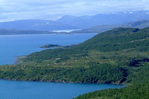
| Virihaure from the south; the Vastenjaure in the background | ||
| Geographical location | Padjelanta National Park (Northern Sweden ) | |
| Tributaries | Miellätno , Stalojåkkå | |
| Drain | Drain to Vastenjaure | |
| Places on the shore | Staloluokta | |
| Data | ||
| Coordinates | 67 ° 24 ' N , 16 ° 33' E | |
|
|
||
| Altitude above sea level | 578.7 m above sea level | |
| surface | 112.45 km² | |
| volume | 4,428 km³ | |
| Maximum depth | 138 m | |
| Middle deep | 39.4 m | |
| Catchment area | 1370 km² | |
The Virihaure is the largest natural lake in the Swedish Padjelanta National Park with an area of 112 km². It is 579 m. ü. M. tributaries include the Miellätno and Stalojåkkå . With a depth of 138 m, it is the sixth deepest Swedish lake. The Virihaure flows in an impressive rapids in the Vastenjaure . In summer it can only be reached on foot, by helicopter or seaplane. The name is derived from the Sami language and means: "water that the wind ripples". In summer the hut village of Staloluokta is inhabited by Sami people. There is also a mountain station for hikers here.
There are several islands in the lake, the largest of which is Stuorsuoloj .
Individual evidence
- ↑ Sjöareal och sjöhöjd (3.32 MB; PDF) , Svenskt vattenarkiv (SVAR), Sveriges meteorologiska och hydrologiska institut (Swedish)
- ↑ a b c Sjödjup och sjövolym (712.6 kB; PDF) , Svenskt vattenarkiv (SVAR), Sveriges meteorologiska och hydrologiska institut (Swedish)
- ↑ VattenWeb , Sveriges meteorologiska och hydrologiska institut (Swedish)


