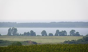
Jezioro Kopań
| Jezioro Kopań ( Lake Vitter ) | ||
|---|---|---|

|
||
| Geographical location | Poland , West Pomeranian Voivodeship | |
| Places on the shore | Wicie ( Vitte ), Kopań ( Kopahn ), Palczewice ( Palzwitz ) | |
| Location close to the shore | Darłowo ( Rügenwalde ), Sławno ( Schlawe ) | |
| Data | ||
| Coordinates | 54 ° 28 '55 " N , 16 ° 27' 2" E | |
|
|
||
| surface | 7.9 km² | |
| length | 5 km | |
| width | 2.2 km | |
| Maximum depth | 3.9 m | |
| Middle deep | 1.9 m | |
The Jezioro Kopań , German Vitter See , is an inland lake in the Polish West Pomeranian Voivodeship . The body of water is located in Western Pomerania , in the district of Sławno ( Schlawe ) in the area of the rural community Darłowo ( Rügenwalde ).
The Vitter See, 10 kilometers northeast of Darłowo ( Rügenwalde ) and 20 kilometers northwest of Sławno ( Schlawe ), is a beach lake in close proximity to the Baltic Sea . Located on the lake are the localities Kopań (eponymous place in Polish, Kopahn ) in the south, Wicie ( Vitte , eponymous place in German) in the northeast and Palczewice ( Palzwitz ) in the east.
With a length of 5 kilometers and a width of 2.2 kilometers, the lake covers an area of 7.9 km². Its average depth is 1.9 meters and its maximum depth is 3.9 meters. It is drained to the Baltic Sea through a canal ( deep ). A widespread system of ditches ensures the water flow in the lowland area between Lake Vitter and Lake Vietzker (Polish: Jezioro Wicko ).
The Vitter See is surrounded by a wide belt of reeds . It is very rich in fish and attracts countless water birds.
Since the middle of the 19th century, the shifting dunes have been successfully fixed by covering them with grass sods and plants with beach grass and birch, alder, pine and spruce trees. The beach was secured by installing groynes .
In ancient times, a path called the Amber Road ran over the spit , which is up to 75 meters wide . In 1939 a landing pad for gliders was built on the lake.
literature
- The Schlawe district. A Pomeranian Heimatbuch , ed. by Manfred Vollack, 2 volumes, Husum, 1988/1989
