Sławno
| Sławno | ||
|---|---|---|

|
|
|
| Basic data | ||
| State : | Poland | |
| Voivodeship : | West Pomerania | |
| Powiat : | Sławno | |
| Area : | 10.14 km² | |
| Geographic location : | 54 ° 21 ′ N , 16 ° 40 ′ E | |
| Residents : | 12,511 (Jun. 30, 2019) |
|
| Postal code : | 76-100 | |
| Telephone code : | (+48) 59 | |
| License plate : | ZSL | |
| Economy and Transport | ||
| Street : | DK 6 Kołbaskowo ↔ Pruszcz Gdański | |
| Ext. 205 Darłowo ↔ Bobolice | ||
| Rail route : | PKP No. 202 ( Stargard in Pomerania – Danzig ) | |
| Next international airport : | Szczecin-Goleniów | |
| Gmina | ||
| Gminatype: | Borough | |
| Surface: | 10.14 km² | |
| Residents: | 12,511 (Jun. 30, 2019) |
|
| Population density : | 1234 inhabitants / km² | |
| Community number ( GUS ): | 3213021 | |
| Administration (as of 2012) | ||
| Mayor : | Krzysztof Frankenstein | |
| Address: | ul. Curie-Skłodowskiej 9 76-100 Sławno |
|
| Website : | www.slawno.pl | |
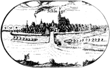
Sławno [ 'swavnɔ ] ( German Schlawe ) is a city in the Polish West Pomeranian Voivodeship . It is the county seat of the Powiat Sławieński and the seat of the independent rural community Sławno .
Geographical location
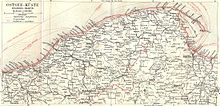
The city is located in Western Pomerania on the Wipper , halfway between Köslin ( Koszalin ), 35 km, and Stolp ( Słupsk ), 27 km.
At the place the Motze (Polish. Moszczenica ) flows into the Wipper.
history
middle Ages
A Kashubian settlement called "Zlauinia" was mentioned in writing for the first time around 1186 , until the end of the 13th century the place name changes between Slawo, Slauno and Slav.
For centuries the place gave its name to the “Schlawer Land”, an area that was ruled by changing rulers like no other in Pomerania. The first surviving duchy was Pommern-Schlawe-Stolp under Duke Ratibor I from the noble family of the Griffins , who resided at Schlawe Castle until his death around 1155. His descendants ruled there until 1227, after which Swantopolk II , Duke of Pomerania , acquired the land of Schlawe. After Swantopolk II's death in 1266, Duke Barnim I of Pomerania occupied the land and handed it over to Duke Wizlaw II of Rügen as a pledge in 1270 . Around 1275 it was ousted from Schlawe by Duke Mestwin II of Pomerania. He had no male heirs and concluded a succession contract with Przemysław II , Duke of Greater Poland , unilaterally on February 15, 1282, regardless of previously entered into contracts as well as inheritance rights with related Pomeranian dukes . After his assassination in 1296, Władysław I. Ellenlang , the Duke of Kujawy , succeeded him on the Pomeranian ducal throne. In 1299, the Bohemian King Wenceslaus II ousted his Polish rival Władysław I in the struggle for supremacy in the Kingdom of Poland , after which he took over its Polish rulers, including the Pomeranian country of Schlawe. In 1300 Wenceslaus II crowned himself King of Poland. After the assassination attempt on Wenceslaus III. , 1306, Władysław I. prevailed again as sovereign over large parts of Poland and Pomerania.
The Swenzones , a family of Pomeranian officials in the service of the Bohemian rulers, rose up against Polish rule . In 1307 they asked the Margrave of Brandenburg for assistance, who intervened militarily in Pomerania in 1308. In the Treaty of Soldin , the Polish Duchy of Pomerania was finally divided between two German feudal states in 1309. The lands of Schlawe, Stolp, Rügenwalde and Bütow remained near Brandenburg, the larger remainder with the main fortress of Danzig went to the Teutonic Order .
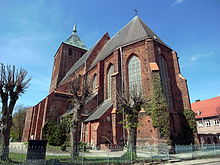
But already with the Peace of Templin , the Pomeranian Duke Wartislaw IV. Acquired all Pomeranian lands that were under the sovereignty of the Mark Brandenburg in 1317 , including the Land of Schlawe. This came again under the rule of the Pomeranian Griffin family, where it remained until its extinction in 1637. After Duke Wartislaw IV. Had acquired Schlawe, he built a strong castle there to defend against and protect against the Teutonic Order. In 1317 by Schlawe was Peter von Neuenburg of the family of swienca family that the Schlawer country by the Duke Wartislaw IV. To feudal took the city charter by Lübischem rights conferred. Around 1360 the Duchess Sophia, wife of the Pomeranian Duke Barnim IV , donated the Marienkirche in Schlawe, which was built in the Gothic style .
During this time, the duchies alternated several times due to the dynastic divisions , Pommern-Wolgast followed in 1372 Pommern-Schlawe-Stolp, 1403 Pommern-Rügenwalde, in 1457 again Pommern-Wolgast and 1532 Pommern-Stettin.
Early modern age
At the beginning of the 16th century, the city developed into an important center for the linen trade . In the Thirty Years' War , 1618–1648, Schlawe got between the fronts and was almost completely destroyed. At the end of the war there were said to have only been 40 households. After the end of the Thirty Years' War, in 1648, Schlawe and large parts of Western Pomerania were added to the Electorate of Brandenburg.
The city recovered, however, so that it was raised to the rank of Brandenburg district capital in 1720. The connection to the new road from Stettin to Gdansk brought further progress .
19th and 20th centuries
Since 1815 Schlawe belonged to the then formed Prussian province of Pomerania .
When industrialization began in Germany in the middle of the 19th century , this was also noticeable in Schlawe. From 1850, several sawmills and mills, two iron foundries and an agricultural machinery factory were built in rapid succession. In 1869 the station opened on the new railway line Berlin, Stettin, Danzig, and in 1878 the railway line to Rügenwalde began operations. The population, which grew from 5141 to 6620 between 1875 and 1910, was supplied with the new energy sources, after a gas works was completed in 1896, the city was electrified from 1911. In 1918 Schlawe became the district town of the district of the same name . In 1928 the small Catholic community built the parish church of St. Anthony of Padua. At the end of the Weimar Republic , Schlawe had grown into a small industrial center with 18 companies.
After the National Socialists had closed the Preachers' Seminar of the Confessing Church in Finkenwalde , which was headed by Dietrich Bonhoeffer , Bonhoeffer was formally employed as assistant preacher at Superintendent Eduard Block in Schlawe. So he was able to continue the illegal training of vicars in two “collective vicariats” in Schlawe and Köslin .
At the beginning of 1945, towards the end of the Second World War , the population had to flee from the advancing Red Army . In March 1945, the city was captured by Soviet troops after being half destroyed. Many Germans, whose houses had survived the bombing raids, returned after the escape. The city was then placed under Polish administration by the Soviet Union . The old residents of Schlawe were expelled and replaced by immigrating Poles .
Under the Polish administration, the food industry, the wood processing industry and the clothing industry were reactivated. In the course of the reorganization of the area administration, Sławno became the district capital, but lost this status again in 1975. In 1960 the Polish state began to rebuild the city, which was still largely in ruins. It developed. After the end of communism, it became possible to build modern housing developments in the north of the city. In 1999 Sławno was again the district capital.
Population development
| year | Residents | Remarks |
|---|---|---|
| 1740 | 1453 | |
| 1782 | 1602 | including 18 Jews |
| 1791 | 1682 | including 13 Jews |
| 1794 | 1702 | including 13 Jews |
| 1812 | 2112 | including a Catholic and 42 Jews |
| 1816 | 2293 | including 14 Catholics and 87 Jews |
| 1831 | 2886 | including 14 Catholics and 167 Jews |
| 1843 | 3535 | including 16 Catholics and 208 Jews |
| 1852 | 4187 | including 22 Catholics and 188 Jews |
| 1861 | 4375 | including 32 Catholics and 250 Jews |
| 1871 | 4724 | of which 4,448 Protestants, 17 Catholics, nine other Christians and 250 Jews |
| 1875 | 5141 | |
| 1880 | 5565 | |
| 1890 | 5431 | 102 Catholics and 163 Jews |
| 1910 | 6620 | |
| 1925 | 7892 | 7,438 Protestants, 91 Catholics and 90 Jews |
| 1933 | 8730 | |
| 1939 | 9746 | |
| 1944 | 9708 | |
| 1947 | approx 4800 | |
| 1999 | approx. 14,000 |
Town twinning
- Ribnitz-Damgarten (Germany, Mecklenburg-Western Pomerania)
- Rinteln (Germany, Lower Saxony)
- Trento (Italy)
Attractions
- City parish church of the Holy Virgin Mary (Gothic, 14th century)
- City office, built around 1900, with interesting stained glass: coats of arms of the places in the German district of Schlawe and the arms of the aristocracy of the landowners of the district
- Remains of the city wall with two Gothic gates: Kösliner (1453) and Stolper Tor (1458) (Polish: Brama Koszalińska and Brama Słupska )
- Forest reserve " Sławieńskie Dęby "
traffic
To town leading national road 6 , while European route E28 , on the banks of the Wipper ( Wieprza ). The Ostseebad Rügenwaldermünde ( Darłówko ) can be reached on the voivodship road 205 after 20 km, but there was also a rail connection ( Korzybie – Darłowo ).
Personalities
sons and daughters of the town
- Georg Salemann (1597–1657), German-Baltic Evangelical-Lutheran clergyman, author and translator
- Nikolaus Bertram von Below (1728–1779), Prussian Chamber President
- Friedrich Theodor Rinck (1770–1811), German Protestant theologian, philosopher, university professor
- Otto von Drigalski (1788–1860), Prussian lieutenant general and commander of the 14th division
- Carl Friedrich von Denzin (1800–1876), German conservative politician
- Berthold Heberlein (1846–1914), German Protestant theologian
- Franz Mehring (1846–1919), German politician (SPD, USPD, KPD), historian and publicist
- Hermann Kühn (1851–1937), German tax officer, State Secretary in the Reich Treasury
- Albert Römer (1859–1909), German author and editor
- Hermann Klaje (1868–1945), German high school teacher and historian
- Otto Hasse (1871–1942), German officer, most recently General of the Infantry and Chief of the Troops Office in the Reichswehr Ministry
- Hans Bredow (1879–1959), German high-frequency technician, chairman of the Reichs-Rundfunk-Gesellschaft
- Wilhelm Groß (1883–1974), German sculptor, printmaker and preacher
- Otto Priebe (1886–1945), German painter
- Erwin Gohrbandt (1890–1965), German surgeon and university professor
- Rudolf Michael (1896–1972), German local politician (SPD), District Councilor for Labor in Berlin-Zehlendorf
- Hans-Martin Majewski (1911–1997), German film composer
- Erna Witt , b. Bannow (1911-2006), German mathematician and politician (FDP)
- Günter Machemehl (1911–1970), German painter
- Erica Wallach (1922–1993), German-American teacher, editor and translator
- Arwed Imiela (1929–1982), German serial killer
- Eberhard Mellies (1929–2019), German actor, radio play speaker and voice actor
- Walter Klock (* 1930), German bodybuilding functionary
- Otto Mellies (1931–2020), German actor, radio play speaker and voice actor
- Hans Burzlaff (* 1932), German physicist and crystallographer, former chairman of the German Society for Crystallography
- Hildegard Schmahl (* 1940), German actress
- Peter Haeske (* 1941), German politician (CDU), former member of the state parliament in Mecklenburg-Western Pomerania
- Klaus Buß (* 1942), German politician (SPD), former minister in Schleswig-Holstein
- Wolfgang Weber (* 1944), German soccer player
- Krzysztof Włodarczyk (* 1961), Polish clergyman, auxiliary bishop in Köslin-Kolberg
- Marcin Wasilewski (* 1975), jazz musician
- Agnieszka Włodarczyk (* 1980), actress and singer
- Marlena Karwacka (* 1997), track cyclist
Personalities associated with the city
- David Ruhnken (1723–1798), scholar and librarian, attended the Latin school in Schlawe until Easter 1739.
Honorary citizen of the city
- 1895: Otto von Bismarck (1815–1898), Reich Chancellor
- 1915: Hermann Kühn (1851–1937), State Secretary in the Reich Treasury
- 1915: Hubert von Michaelis (1858–1925), manor owner, Major a. D., member of the Reichstag and the Prussian mansion, district deputy of the Schlawe district
- 1927: August Steinhorst (1853–1937), city elder and councilor of the city of Schlawe
Gmina Sławno
The town of Sławno is the official seat of the rural community ( gmina wiejska ) Sławno, although the urban area is not part of the municipality. The rural community has an area of 284.20 km², which includes the entire urban area, and a population of 8857 (June 30, 2019).
literature
- Gustav Kratz : The cities of the province of Pomerania. Outline of their history, mostly according to documents. A. Bath, Berlin 1865 (reprinted in 1996 by Sendet Reprint Verlag, Vaduz, ISBN 3-253-02734-1 ), pp. 346–354 ( full text )
- Our Pommerland Jg. 10, H. 5: Schlawe-Rummelsburg .
- Manfred Vollack (Ed.): The Schlawe district. A Pomeranian homeland book. Volume 1, Husum Verlag, Husum 1986, ISBN 978-3-88042-239-1 . Volume 2 The cities and rural communities , 2nd edition. Husum Verlag, Husum 1997, ISBN 3-88042-337-7 .
- Sławno: dawne fotografie i pocztówki = Schlawe: old photographs and postcards . Sławno 2002, ISBN 83-917381-0-8 .
- Ludwig Wilhelm Brüggemann (ed.): Detailed description of the current state of the Royal Prussian Duchy of Western and Western Pomerania . Volume 2, Stettin 1784, pp. 839-841 ( full text ).
- Johann Ernst Fabri : Geography for all classes . Part I, Volume 4, Leipzig 1793, p. 578 ( full text ).
Web links
- Gunthard Stübs and Pomeranian Research Association: The city of Schlawe i. Pom. in the former Schlawe district in Pomerania (2011)
- Rolf Jehke: City of Schlawe i. Pom. (2014)
- Historical city map from 1935 (PDF; 5.1 MB)
- Church records archived in the Schlave district .
- City website (Polish)
- Gmina website (Polish)
- BIP Gmina (Polish)
Individual evidence
- ↑ a b population. Size and Structure by Territorial Division. As of June 30, 2019. Główny Urząd Statystyczny (GUS) (PDF files; 0.99 MiB), accessed December 24, 2019 .
- ↑ cf. z. B. Udo Arnold and Marian Biskup (eds.): The German Order State Prussia in the Polish historiography of the present (= sources and studies on the history of the German Order , Volume 30). Verlag Wissenschaftliches Archiv, Bad Godesberg 1982, especially p. 130.
- ↑ Martin Wehrmann : History of Pomerania . Volume 1. 2nd edition. Friedrich Andreas Perthes, Gotha 1919, p. 121. Reprint: Weltbild Verlag, Augsburg 1992, ISBN 3-89350-112-6 .
- ↑ Dietrich Bonhoeffer: Works , Vol. 15: Illegale theologenausbildung. Collective Vicariates 1937–1940 . Edited by Dirk Schulz. Kaiser, Gütersloh 1998, ISBN 3-579-01885-X , p. 5.
- ↑ Josef Ackermann: Dietrich Bonhoeffer - freedom has open eyes. A biography . Gütersloher Verlagshaus, Gütersloh 2005, p. 159.
- ↑ a b c d e f g h i Gustav Kratz : The cities of the province of Pomerania. Outline of their history, mostly according to documents. A. Bath, Berlin 1865 (reprinted in 1996 by Sendet Reprint Verlag, Vaduz, ISBN 3-253-02734-1 ), pp. 346–354, especially p. 353.
- ↑ Christian Friedrich Wutstrack : Brief historical-geographical-statistical description of the royal Prussian duchy of Western and Western Pomerania . Stettin 1793, overview table on p. 736.
- ^ Prussian State Statistical Office: The municipalities and manor districts of the Prussian state and their population (VIII. Kreis Schlawe) . Berlin 1873, pp. 136-137, no. 105.
- ↑ a b c d e Michael Rademacher: German administrative history from the unification of the empire in 1871 to the reunification in 1990. Schlawe.html # ew39sclwrschlwe. (Online material for the dissertation, Osnabrück 2006).
- ↑ http://wiki-de.genealogy.net/GOV:Object_335734 ( page no longer available , search in web archives ) Info: The link was automatically marked as defective. Please check the link according to the instructions and then remove this notice.
- ↑ The city of Schlawe i. Pom. in the former Schlawe district in Pomerania (Gunthard Stübs and Pomeranian Research Association, 2011)
- ^ Rolf Jehke: City of Schlawe i. Pom. (2014)
- ↑ http://slawno.pl/


