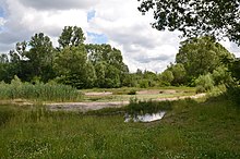
Volkspark Marienberg
The Volkspark Marienberg (also: Marienbergpark ) is an English-style landscape garden in the north of Nuremberg and the second largest public park in the city. Volkspark Marienberg is also the name of District 831 in District 83 Marienberg , whose area is not identical to the green corridor.
The location
The park is four kilometers north of the center of Nuremberg in the Großreuth district behind the fortress at an altitude of about 315 m above sea level. NN . It is limited to the north by Marienbergstrasse and Kilianstrasse to the south. In the east, the districts of Herrnhütte and in the west, Kleinreuth, close off the area behind the fortress . The airport is two kilometers to the northwest .
history
In the 19th century the area was still wooded until a Nuremberg factory owner built a manor in 1845. This also included an inn, where the “Tucherhof beer garden” is located today. The Tucher family took over the property and created ponds for ice extraction. The largest of them became an excursion destination, expanded into a bathing establishment in 1926 and was operated as the "Frankenbad" until the recent past. To the east of it, the model farm "Mooshof" was built in 1888.
As the successor to the Fürth airfield in Atzenhof , the new Nuremberg-Marienberg Airport was decided on in 1929 on 140 hectares. The economic crisis, unemployment and politically troubled times delayed construction until it opened in August 1933 - now as a prestige object for the National Socialists.
In September 1939 it was placed under the Air District Command XIII and almost completely destroyed by an air raid in 1943. Today there are only a few traces left of the airfield. The Nuremberg waste management and city cleaning buildings are located on the site of the former terminal, the former aircraft hangars are now used for repair and maintenance of vehicles and the "old guard", a small house, has become the home of the caretaker. The airfield has become garden colonies and a park.
Only if you look closely can you still discover the remains of the runway. After the Second World War, the airfield was moved further north to its current location. Marienbuck, almost twenty meters high, was heaped up from the rubble of the ruins .
Until 2002, the only drive-in cinema in Nuremberg was located just north of the park. With its 14 rows it contained 1,111 vehicles. On Saturdays, the square was also used as a private automobile market.
park
Between 1959 and 1973, an English landscape park with a variety of sports and play facilities was created on 120 hectares and a pond was created. Allotment garden colonies also found space here. The Marienbuck was designed as a toboggan and viewing hill. A spawning pool has been created by the Federation of Nature Conservation for the very rare common garlic toad. A small arboretum was created for the anniversary year 2000 . Rare trees have been planted around the pond.
Web links
Individual evidence
- ↑ City map service Nuremberg: District 831 Volkspark Marienberg
- ^ Wiltrud Fischer-Pache: Marienberg . In: Michael Diefenbacher , Rudolf Endres (Hrsg.): Stadtlexikon Nürnberg . 2nd, improved edition. W. Tümmels Verlag, Nuremberg 2000, ISBN 3-921590-69-8 , p. 670 ( complete edition online ).
- ↑ Drive-in cinema Nuremberg
- ↑ federal conservation Nuremberg: Nature walks in Nuremberg, Nuremberg 1998 Tour 6
Coordinates: 49 ° 28 '49.1 " N , 11 ° 5' 28.7" E


