Votorantim
| Votorantim | ||
|---|---|---|
|
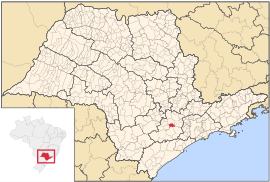
Coordinates: 23 ° 33 ′ S , 47 ° 26 ′ W Votorantim on the map of São Paulo
|
||
|
Location of the municipality of Votorantim in the state of São Paulo
|
||
| Basic data | ||
| Country | Brazil | |
| State | São Paulo | |
| Residents | 108,809 (IBGE / 2010) | |
| City insignia | ||
| Detailed data | ||
| surface | 183.998 | |
| Population density | 591.04 inhabitants / km 2 | |
| height | 570 m | |
| Time zone | UTC −3 | |
| City Presidency | Fernando de Oliveira Souza ( DEM ) | |
| Website | ||
Votorantim is a Município in the southwest of the state of São Paulo in Brazil . An estimated 122,480 inhabitants lived in Votorantim in 2019.
history
The area around Votorantim was settled in the mid-seventeenth century. In 1679 a chapel was built there. The Portuguese immigrant Antônio Pereira Inácio founded the Brazilian company Grupo Votorantim in the city in 1918 . About 15,000 people lived in the city in the late 1950s. On December 1, 1963, Votorantim became a municipality with a referendum. The first local elections then took place on March 7, 1965. Pedro Augusto Rangel became the first mayor.
sons and daughters of the town
- William Amorim (born 1991), football player
Web links
Commons : Votorantim - collection of images, videos and audio files
- Official website of Votorantim
- IBGE : Cidades @ São Paulo: Votorantim. Retrieved August 29, 2019 (Brazilian Portuguese).
Individual evidence
- ^ History of the Grupo Votorantim, accessed on September 22, 2010
- ^ History of Votorantim, accessed September 22, 2010


