
Wadi al-Gimal-Hamata


The Wadi al-Gimal – Ḥamata National Park (also Wadi-el-Gemal National Park ; named after the Wadi al-Gimal , Arabic وادي الجمال, DMG Wādī al-Ǧimāl , German "Valley of the Camels" ) is one of three national parks in Egypt . The transcriptions Gemel, Gimal, Gemal and Jimal are also used. With an area of 7450 km² it is the smallest of the three protected areas of the Arabian Desert , after the protected areas of Elba and Wādī al-ʿAlāqī . It is located around 50 kilometers south of Marsa Alam and extends from the coast of the Red Sea in the east to around longitude 34 ° 28 'East in the west, i.e. around 70 kilometers inland.
geography
The rift unfolding of the mountain range on the Red Sea consists of jagged basalt and granite formations and reaches its greatest height in the Gebel (Arabic = mountain) Shayib al-Banat with 2187 m. The catchment area of the precipitation area is 1840 km² and extends from the northern flank of the Gebel Hamata in the south to the southern flank of the Gebel Nugrus in the north. Other high mountains are the Gebel Hafafit, Gebel Hamamid, Gebel Sartut and Gebel Sikeit.
The nature reserve also includes other wadis such as Wadi Abu Ghusun , Wadi el Ringa and Wadi el Rada . The boundaries of the terrestrial portion are the highlands of Ras Baghdadi, Ras Hankorab and Sharm el-Luli Bay.
Integrated is a mangrove-covered coastal and sea strip with an average width of 15 km with four also many mangrove- bearing islands of the Qul'an Archipelago (also Hamata Islands , four islands from north to south: Siyal, Shawarit, Umm al-Shayk, Mahabis, plus a nameless tidal island ) and the Wadi el-Gamal Island in the far north of the area , which can be seen on the horizon.
biodiversity
The park is home to many different species. Camels and wild monkeys live here, and the mangrove forests provide a habitat for many species of birds. The lake area is also home to seagrass meadows where manatees , sea turtles and many fish species find food.
Before the animal world of the East African savannah became well known with the Thomson and Grant's gazelles , the Dorcas gazelle ( Gazella dorcas ) was considered a typical gazelle . It is the largest population in Egypt, but with an estimated 25-30 animals, they are endangered species. The IUCN classifies the species as endangered. In addition, you can meet the shy Syrian or Nubian ibex ( Capra ibex nubiana ) , which are also endangered in the population .
The African (wild) donkey ( Equus asinus syn. E. africanus ) disappeared from large parts of its distribution area as early as Roman times and is a highly endangered species in the wild. The mane jumper ( Ammotragus lervia ) stands between sheep and goats. The name Ammotragus comes from the Greek and literally means "sand goat", the name "Aoudad" from a Berber language, which is common in the English-speaking area.
The largest colony of the shale falcon ( Falco concolor ) in the world is located on Wadi el Gamal Island . Its breeding season is from August to September and moves to Madagascar in October . Due to their small number, they are already on the Red List of the International Union Conservation of Nature (IUCN). The island was also occupied by a large colony (75% of the total population) of the also endangered white-eyed gulls ( Larus leucophthalmus ) , which only breed in the Red Sea and the Gulf of Aden - with an orange-red beak and deep black wing cover . There is also a small colony on Giftun Island off Hurghada , but most of them prefer the island in front of Wadi el Gamal. Both species are now classified as endangered by the IUCN.
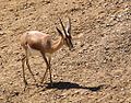
Dorcas Gazelle

Nubian ibex

African wild ass

White-eyed gull


particularities

The area was only granted the status of nature park by decree in January 2003 and is home to a diverse range of flora and fauna compared to the desert conditions.
It is forbidden to enter the national park without a ranger, vehicles such as off-road motorbikes or quads are not officially allowed.
Historically significant places from Roman and Ptolemaic times are located in the park.

On the reef, from the street visible is the wreck of the Sea Lion I . A little further south at Abu Ghusun (Abu Gosoon) lies the Hamada on the reef at a depth between 10 and 18 meters, which is accessible to divers. The latter had loaded plastic granules, the remains of this load can still be found on the beach in Abu Ghusun.
Individual evidence
- ^ Official map of the protected areas in Egypt
- ↑ a b c Wadi el Gemal National Park, marsa-alam.org
- ↑ Tamer Mahmoud: Desert Plants of Egypt's Wadi el Gemal National Park , page 6: " Extending northeast from Hamata is the Qul'an Archipelago — sometimes called the Hamata Islands "
- ↑ a b World Heritage Convention - Red Sea Junior Rangers in Wadi El-Gimal National Park, EGYPT (pdf; 233 kB) ( Memento of the original from February 27, 2015 in the Internet Archive ) Info: The archive link was inserted automatically and has not yet been checked . Please check the original and archive link according to the instructions and then remove this notice.
- ↑ Hamada at Shipwrecks of Egypt ( Memento from July 22, 2010 in the Internet Archive )
Web links
Coordinates: 24 ° 26 ' N , 34 ° 52' E