
Rimal Al Wahiba

| |
Rimal Al Wahiba in Oman |

The Rimal Al Wahiba , Wahiba Sands or Scharqiyya Sands ( Arabic رمال آل وهيبة, DMG Rimāl Āl Wahība ) is a desert in the Janub al-Sharqiyya region in eastern Oman . The area extends for 180 km from north to south and is about 80 km wide. The area covers around 12,500 km².
Ghaf trees ( Prosopis cineraria ) grow here, and in winter the desert turns green in places.
The large dunes in the north run parallel to each other in a north-south direction, as can even be seen on the satellite image. In between there are two funnel routes between the dunes, which Bedouins and visitors use four-wheel drive vehicles several times a day. These routes are not marked out or paved, but are formed exclusively by tire tracks from preceding vehicles. About 20 kilometers south of the north end there are several tourist camps, some of which can now also be reached via a gravel road. In the middle of the Wahiba Sands there are some Bedouin dwellings. In the meantime, individual people from India and Bangladesh even live there.
In summer it gets extremely hot in the Wahiba Sands. Driving is then only recommended in the early morning hours. Regardless of the time of year, a very large supply of water, as well as replacement petrol (very high consumption in deep sand) and material for clearing a vehicle from deep sand should always be carried with you. A second car also ensures mutual safety and sometimes allows the other car to be pulled out of deep sand.
Photo gallery
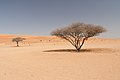
Umbrella acacia
( Vachellia tortilis )
Dromedaries as local desert fauna

Wahiba Sands

Wahiba Sands

.jpg)
.jpg)
.jpg)
Web links
- "Ramlat al-Wahiba: The Model Desert" at Spiegel-Online
Coordinates: 22 ° 0 ' N , 58 ° 50' E