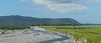
Waitangitaona River
| Waitangitaona River | ||
|
View of the Waitangitaona River from the bridge of New Zealand State Highway 6 looking north |
||
| Data | ||
| location | West Coast , South Island , New Zealand | |
| Glacier in the Tatar Range | North of McFetrick peak ( 2,188 m ) 43 ° 23 '7 " S , 170 ° 18' 53" O |
|
| Source height | 1560 m approx. | |
| muzzle |
Tasman Sea Coordinates: 43 ° 14 ′ 58 " S , 170 ° 16 ′ 32" E 43 ° 14 ′ 58 " S , 170 ° 16 ′ 32" E |
|
| Mouth height | 0 m | |
| Height difference | 1560 m | |
| Bottom slope | 35 ‰ | |
| length | 45 km | |
| Left tributaries | Waitangiroto River | |
| The river split into two parts after a flood in 1967. | ||
The Waitangitaona River was a 45 km long river in the West Coast region of the South Island of New Zealand . After a flood in 1967, the river split into two parts. A name change to Waitangitāhuna River followed in December 2018. On maps, the river is often referred to as the Waitangitaona River .
geography
The current parts of the river are divided into an upper, southern part, here under the Waitangitāhuna River (Upper) and a lower, northern part, here under the Waitangitāhuna River (Lower) .
history
In March 1967, a flood changed the Waitangitaona River bed . The tide diverted the river, which previously turned east 1.7 km east of Lake Wahapo , now west and fed from now on to the adjacent lake. A small part of the river also supplied the eastbound Graham Creek , which flowed into the old riverbed of the river. Hydraulic engineering measures that took place in the mid-1980s finally ensured that any re-occurring floods could no longer change the river bed. This sealed the division of the river into two parts.
In October 2017, the New Zealand Geographic Board accepted the proposal to rename the lower northern part of the Waitangitaona River to Waitangitāhuna River , as the spelling of the river had been translated incorrectly in the 19th century and should now be corrected. The upper, southern part of the river, however, should be called the Waitakitāhuna-ki-te-Toka River , so that the two rivers, now running independently of each other, could be distinguished.
In another meeting of the New Zealand Geographic Board , the request of the locally based Māori was granted to change the name of the two new parts of the river uniform to Waitangitāhuna River , which happened with the publication in the government gazette on December 20, 2018.
Individual evidence
- ↑ a b Waitangitaona River . In: NZ Topo Map . Gavin Harriss , accessed December 30, 2019 .
- ↑ a b Waitangitāhuna River . In: New Zealand Gazetteer . Land Information New Zealand , December 20, 2018, accessed December 30, 2019 .
- ↑ Submissions for : Waitangitāhuna River - Waitakitāhuna-ki-te-Toka River . In: NZ Geographic Board . Land Information New Zealand , April 12, 2018, accessed December 30, 2019 .
- ^ Notice of Final Determinations of the Minister for Land Information on Official Geographic Names . In: New Zealand Gazette . Minister for Land Information , December 20, 2018, accessed December 30, 2019 .
