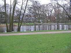
Waller Park
| Waller Park | |
|---|---|
| Park in Bremen | |

|
|
| Pond in the park | |
| Basic data | |
| place | Bremen |
| District | Walle |
| Created | From 1833 |
| Newly designed | 1928, 2005 |
| Surrounding streets | Ackerstraße Waller Heerstraße Long Row |
| use | |
| Park design | 1928: Paul Freye |
| Technical specifications | |
| Parking area | 29 hectares |
The Waller Park is located in Bremen in the district Walle , the district Walle next to Waller Cemetery .
history
Manor and aristocratic residence
In 1179 the Hof-Walle is mentioned. The gentlemen at Walle were archbishop servants and Bremen councilors and bailiffs. The knight and patrician family died out in the 15th century. In 1635 the knight Christoph Ludwig Raschen , Lieutenant Colonel in Brandenburg and Swedish diplomat during the Thirty Years' War , leased the farm as a retirement home.
The Walle estate came into the possession of the Achelis family in 1833. She built herself a "pleasure seat" by the lake, expanded the property through purchases and designed the gardens into a splendid landscape park .
Volkspark for Walle
In 1928 the city bought the property from the impoverished estate park owners. Garden director Paul Freye can initially only realize 6 hectares of the 35 hectare area as a public park for the workers and petty bourgeoisie living here. Games and sport, nature and relaxation, culture and social affairs came together. The large mansion was converted into a house of culture and communication with film screenings, offers for young and old, a library, readings and a café. Around the lake, the park was supplemented by new paths, a toboggan hill, lawn, oaks, linden trees, chestnuts, black pines and rhododendrons.
The building in the park was destroyed in the Second World War, the trees were preserved. In 2005, the Bremen environmental company transformed the old playground in the park into a play area for everyone with a cable car, tree house and scooter course.
The Waller Park became an important local recreation area for the west of Bremen through the adjoining park cemetery from 1875, expanded from 1937 and from 1957 to 29 hectares.
literature
- Peter Schulz, Peter Fischer (cards): Parks in Bremen . Bremer Marketing (ed.), Bremen 2008.
Web links
Coordinates: 53 ° 6 ′ 21 ″ N , 8 ° 46 ′ 33 ″ E