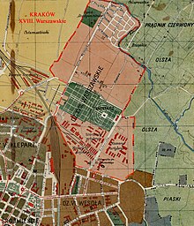
Warszawskie
Warszawskie (also Śródmieście Warszawskie [Warsaw city center], Warszawskie Przedmieście [Warsaw suburb]) is a former district of the city of Krakow in Poland , northwest of Kraków's old town and north of Wesoła or Nowe Miasto , which is now between the old town and the district III Prądnik Czerwony is split.
Until 1910, the area mainly made up part of the Prądnik Czerwony commune south of the Białucha ( Prądnik ) wedged between Krowodrza in the west and Olsza in the east along the road from Kraków (in the south-west) to Warsaw (then Warszawska Street, now 29 Listopada Street) out. The Rakowicki Cemetery was established in the early 19th century . In the years 1850–1856, the “Luneta Warszawska” fortification of the Kraków Fortress was built on the western side of the road. The buildings of the army (thus the seat of the August Emil Fieldorf Museum of the Home Army ) as well as the soldiers' cemetery and the Rakowicki cemetery dominated the southern part of the borough. The barracks in the southwest of Olsza were also attached. In the north near Prądnik Celarowski there were numerous villas.
In 1910 the area was incorporated into Krakow. In 1921, the district XVIII. Warszawskie 2658 inhabitants, of which the majority were Polish (2613) and Roman Catholic (2532).
In the interwar period , the Austrian army was replaced by the Polish one.
Individual evidence
- ↑ Główny Urząd Statystyczny: Skorowidz miejscowości Rzeczypospolitej Polskiej. Województwo krakowskie i Śląsk Cieszyński . Warszawa 1925, p. 17 [PDF: 27] (Polish, Woj.krakowskie i Sląsk Cieszynski miejscowości.pdf ).
literature
- Leszek Grabowski: Dawne przedmieścia Krakowa ulatująca przeszłość. Część LXVIII. Krakowski Kalejdoskop: Warszawskie (Przedmieście), Olsza, Piasek, Czarna Wieś, Wola Justowska, Zwierzyniec, Przegorzały, Dębniki, Zakrzówek, Ludwinów, Podgórze, Wolaż Duchacka, Polish , Wolaż Duchacka , Poland, Piaseką , Poland, Poland 2015
Coordinates: 50 ° 5 ' N , 19 ° 57' E

