Jarplund-Weding
Jarplund-Weding ( Danish : Jaruplund-Vedding ) is a former municipality south of Flensburg in the north of Schleswig-Holstein and since March 1, 2008 part of the municipality of Handewitt . In 2006 about 4,300 people lived in Jarplund-Weding on a community area of 13.22 km². The western district of Weding has now merged with Flensburg-Weiche. Jarplund is separated from the city by the Flensburg-Süd junction.
On March 1, 2008, the municipality of Jarplund-Weding merged with the neighboring municipality of Handewitt to form the new municipality of Handewitt , which was free of any office . At the same time, the Office of Handewitt was dissolved.
Altholzkrug, Jarplund and Weding were located in the municipality.
history
On March 24, 1974, the community Jarplund-Weding was formed through the merger of the previously independent communities Jarplund and Weding.
Surname
The name Jaruplund is probably derived from an earlier village name "Hjarup". Today it can be found 3 times in the south of Denmark (1 time near Kolding , 2 times near Aabenraa ) and 1 time on Fyn . Hjarup means "Thorp des Hjor (genitive: Hjara)". Thorp refers to an emigrant farm in Old Danish. Thousands of them were created in Denmark during the Viking Age, recognizable by the endings -strup, -trup, -drup, -derup or -rup. These resettler farms were often given the names of the owners. So was z. B. from Frøthorp (Thorp des Frøi) later Frørup . In the case of Jarplund and Frörup, Oeversee is probably the old mother village. The word "lund" means something like small forest. Weding is probably derived from the old Danish "wad" (for wet) and the suffix "ing", which means that it belongs (e.g. residents of the North Sea island of Föhr are called Föhringer). Wedingers are people who live by the water, or rather on the moor.
Population development
| Jarplund | Weding | Jarplund-Weding | |||
| year | Residents | year | Residents | year | Residents |
|---|---|---|---|---|---|
| 1867 | 261 | 1867 | 175 | ||
| 1871 | 243 | 1871 | 176 | ||
| 1875 | 281 | 1875 | 170 | ||
| 1880 | 320 | 1880 | 216 | ||
| 1885 | 314 | 1885 | 198 | ||
| 1890 | 324 | 1890 | 232 | ||
| 1895 | 288 | 1895 | 245 | ||
| 1900 | 297 | 1900 | 254 | ||
| 1905 | 313 | 1905 | 255 | ||
| 1910 | 338 | 1910 | 342 | ||
| 1919 | 350 | 1919 | 301 | ||
| 1925 | 390 | 1925 | 409 | ||
| 1933 | 425 | 1933 | 381 | ||
| 1939 | 408 | 1939 | 385 | ||
| 1946 | 758 | 1946 | 818 | ||
| 1950 | 774 | 1950 | 831 | ||
| 1956 | 621 | 1956 | 894 | ||
| 1961 | 834 | 1961 | 1288 | ||
| 1970 | 1114 | 1970 | 1405 | ||
| 1987 | 2978 | ||||
coat of arms
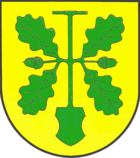
Blasonierung : "In a green gold Torfspaten from whose shaft center on both sides of a green oak branch, each consisting of an acorn between two sheets, deflects."
The peat spade symbolizes the historical peat extraction as an essential livelihood of the local residents in addition to agriculture. At the same time it gives an indication of the meaning of the place name Weding. The oak branches refer to the place name Jarplund and at the same time symbolize the two districts.
Culture and sights
Sports
There are several sports clubs in the village, the most important being TSV Jarplund-Weding , which emerged from the clubs TSV Jarplund and SV Weding. The greatest sporting successes include - in addition to a Bundesliga team in women's handball in the 1980s - winning three German championships (1975 the predecessor club SV Weding in male youth A and 2009 and 2010 each within the framework of the SG Oeversee-Jarplund syndicate -Weding in the female youth A) and a German runner-up in 1983 in the male youth C.
Economy and Infrastructure
In the former municipal area there are extensive industrial areas, the German headquarters of Dänisches Bettenlager is located in the village .
schools
The municipality had a primary school in the Weding district, a primary school in the Jarplund district and a Danish school. The two German primary schools belong to the Handewitter Siegfried Lenz School. Secondary schools (Realschule, Gymnasium) are located a few kilometers away in Flensburg and in Handewitt. The Danish Academy Jaruplund Højskole is located in the Jarplund district .
swell
- ↑ Schleswig-Holstein topography. Vol. 5: Holt - Krokau . 1st edition Flying-Kiwi-Verl. Junge, Flensburg 2005, ISBN 978-3-926055-79-8 , pp. 112 ( dnb.de [accessed July 19, 2020]).
- ^ Federal Statistical Office (ed.): Historical municipality directory for the Federal Republic of Germany. Name, border and key number changes in municipalities, counties and administrative districts from May 27, 1970 to December 31, 1982 . W. Kohlhammer, Stuttgart / Mainz 1983, ISBN 3-17-003263-1 , p. 182 .
- ↑ Christian Karstoft: Course of settlement, the place name Jarplund, the old field names, borders . In: Municipality of Jarplund-Weding (ed.): Chronicle of the municipality of Jarplund-Weding . 1st edition. Selbsverlag, Jarplund-Weding 1999, ISBN 3-00-002339-9 , p. 501 (894 pages).
- ↑ Arthur Christiansen: General, course of settlement, land consolidation, the field names . In: Municipality of Jarplund-Weding (ed.): Chronicle of the municipality of Jarplund-Weding . 1st edition. Selbsverlag, Jarplund-Weding 1999, ISBN 3-00-002339-9 , p. 705 (894 pages).
- ↑ a b The Population of the Communities in Schleswig-Holstein 1867-1970 Chapter 5. Accessed on August 10, 2019.
- ↑ Results of the '87 census. Retrieved August 10, 2019.
- ↑ Schleswig-Holstein's municipal coat of arms
Coordinates: 54 ° 44 ' N , 9 ° 26' E

