Oeversee
| coat of arms | Germany map | |
|---|---|---|

|
Coordinates: 54 ° 42 ' N , 9 ° 26' E |
|
| Basic data | ||
| State : | Schleswig-Holstein | |
| Circle : | Schleswig-Flensburg | |
| Office : | Oeversee | |
| Height : | 31 m above sea level NHN | |
| Area : | 36.26 km 2 | |
| Residents: | 3439 (Dec. 31, 2019) | |
| Population density : | 95 inhabitants per km 2 | |
| Postal code : | 24988 | |
| Primaries : | 04630, 04638, 04602 | |
| License plate : | SL | |
| Community key : | 01 0 59 184 | |
| Office administration address: | Tornschauer Strasse 3–5 24963 Tarp |
|
| Website : | ||
| Mayor : | Ralf Bölck ( CDU ) | |
| Location of the community Oeversee in the Schleswig-Flensburg district | ||
Oeversee [ ˈøvɐzeː ] ( Danish : Oversø ) is a municipality in the Schleswig-Flensburg district in Schleswig-Holstein .
geography
Oeversee is about ten kilometers south of Flensburg on the Treene and on the historic Ochsenweg . The federal motorway 7 runs to the west from Schleswig to Flensburg.

Municipal area
Frörup , Sankelmark and the nature reserve Fröruper Berge belong to the municipality. Furthermore, Augaard ( Danish Ågård ), Barderup , Bilschau ( Bilskov ), Juhlschau ( Julskov ) and Munkwolstrup ( Munkvolstrup ) belong to the municipality.
history
Fortified church
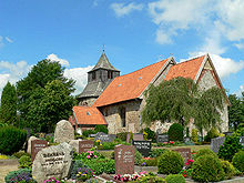
The Romanesque St. George fortified church was built as a field stone church in the 12th century . A round tower with loopholes to the north is attached to the church, which gives it the characteristic of the fortified church. After being destroyed, the defense tower was rebuilt at a later time.
Battle of Oeversee 1864
Oeversee gained notoriety through the Battle of Oeversee in the German-Danish War . On February 6, 1864, the Austrians from the 6th Austro-Hungarian Army Corps, allied with the Prussians, met the Danes there. During the fight, which lasted only a few hours, the Austrians lost 28 officers and 403 common soldiers; the Danes who ran into heavy artillery fire, 18 officers and 944 soldiers. The historical jug , which was privileged by royal Danish standards, served as the headquarters of the Austrians and was also the first field hospital to fly the flag of the newly founded Red Cross .
The residents of Flensburg , about ten kilometers away , still commemorate the help of their citizens for the wounded the day after the battle in an annual Oeversee march from Flensburg- Martinsberg to Oeversee .
Incorporations
On March 24, 1974, the former municipality of Frörup was incorporated.
On March 1, 2008, the municipality of Oeversee merged with the neighboring municipality of Sankelmark , which was newly formed on March 24, 1974 through the merger of the previous municipalities of Barderup and Munkwolstrup, to form the new municipality of Oeversee .
politics
Community representation
Of the 17 seats in the municipal council has CDU since the local elections in 2018 eight seats, the voter community FWG six and the SSW three.
coat of arms
Blazon : “In gold over a shield base divided by a silver wave thread of blue and green and partially covering the silver, blue-roofed tower of the Oeverseer Church, in the upper corners accompanied on the right by two crossed black sabers, on the left by a red mill wheel with black blades . "
Attractions
The list of cultural monuments in Oeversee includes the cultural monuments entered in the list of monuments of Schleswig-Holstein.
The Arnkielpark is an archaeological open-air facility in Munkwolstrup, a district of the Oeversee community.
The "Historische Krug" at Grazer Platz is the oldest inn in Schleswig-Holstein. A fire broke out in the inn on July 30, 2018. The building was completely destroyed. However, this was not the original building, as the restaurant was completely rebuilt after a fire in 1980.
Web links
Individual evidence
- ↑ North Statistics Office - Population of the municipalities in Schleswig-Holstein 4th quarter 2019 (XLSX file) (update based on the 2011 census) ( help on this ).
- ↑ Schleswig-Holstein topography. Vol. 7: Munkbrarup - Pohnsdorf . 1st edition Flying-Kiwi-Verl. Junge, Flensburg 2006, ISBN 978-3-926055-88-0 , p. 234 ( dnb.de [accessed on July 22, 2020]).
- ↑ a b Federal Statistical Office (ed.): Historical municipality register for the Federal Republic of Germany. Name, border and key number changes in municipalities, counties and administrative districts from May 27, 1970 to December 31, 1982 . W. Kohlhammer GmbH, Stuttgart / Mainz 1983, ISBN 3-17-003263-1 , p. 182 .
- ↑ StBA Area: changes from 01.01. until December 31, 2008
- ↑ Schleswig-Holstein's municipal coat of arms
- ^ "AHGZ am Morgen" from August 1, 2018


