Sneeze gray
| coat of arms | Germany map | |
|---|---|---|

|
Coordinates: 54 ° 45 ' N , 9 ° 49' E |
|
| Basic data | ||
| State : | Schleswig-Holstein | |
| Circle : | Schleswig-Flensburg | |
| Office : | Geltinger Bay | |
| Height : | 15 m above sea level NHN | |
| Area : | 9.89 km 2 | |
| Residents: | 529 (Dec. 31, 2019) | |
| Population density : | 53 inhabitants per km 2 | |
| Postal code : | 24395 | |
| Area code : | 04632 | |
| License plate : | SL | |
| Community key : | 01 0 59 148 | |
| Office administration address: | Holmlück 2 24972 Steinbergkirche |
|
| Website : | ||
| Mayor : | Thomas Johannsen (WGN) | |
| Location of the municipality Niesgrau in the Schleswig-Flensburg district | ||
Niesgrau ( Danish : Nisvrå ) is a municipality on the Geltinger Bay in the Schleswig-Flensburg district in Schleswig-Holstein . It has existed in its current form since 1970. Hunhoi ( Hundhøj , also Hunhoved ), Koppelheck (Danish: Kobbelled ), Lipping (Danish also Lepping ), Mühlenkoppel ( Møllekobbel ), Ohrfeldhaff ( Udmarkhav ), Schnogholm ( Snogholm ), Stausmark ( Stavsmark) ), Tollgaard, Stobdrup ( Stubdrup ) and Winnery ( Vinderyd or Vinderyde ) are in the municipality.
history
The large stone grave Ohrfeld dates from the Neolithic Age .
The name Niesgrau is made up of Danish. vrå for corner or angle and the nickname Nis ( originated from Nicolaus in a weak print over Niels ). The place name thus indicates an angle (vrå) that belonged to a man named Nis. In German, the name was reinterpreted in gray due to the omission of the v . Since the late Middle Ages, as in large parts of the parish of Esgrus, the aristocratic estate dominated, first from Rundhof , then on the previously independent Meierhöfe Niesgraugaard and Ohrfeld. The serfdom was abolished already 1765th From 1853 the manor districts were combined to form Kappler harde .
After the Duchy of Schleswig passed to Prussia as a result of the German-Danish War of 1864 , the large parish of Esgrus was divided into nine rural parishes and four manor districts. The area of today's municipality Niesgrau consisted of the small manor districts Niesgraugaard and Ohrfeld and the rural communities Koppelheck, Niesgrau and Stobdrup. The rest of the parish today forms the parishes of Esgrus and Stangheck (including Rundhof).
From 1886 to 1953, the Flensburg circular railway operated in the municipality, so that the center of Niesgrau was formed around the former train station. There were also train stops in Stausmark and Stobdrup.
In 1928 Niesgraugaard were incorporated into Niesgrau and Ohrfeld after Koppelheck, when the aristocratic manor districts were abolished in all of Prussia. In 1970 Koppelheck and Stobdrup were incorporated into Niesgrau. At the same time, the Rundhof-Esgrus district, established in 1889, was incorporated into the Steinbergkirche .
politics
Community representation
Since the municipal elections in 2013, the WGN electoral community has all nine seats in the municipal council.
coat of arms
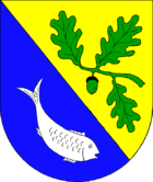
Blazon : “Divided diagonally by gold and blue. Above a green oak branch consisting of three leaves and an acorn, below a silver fish swimming to the left. "
economy
The community is predominantly agricultural, but tourism is also an important source of income.
In Niesgrau there was a ferry port from which ships went to the Danish island of Funen . With the discontinuation of the butter trips , the ferry service was no longer profitable and was given up. Today the area is used, among other things, as a sports boat harbor.
Good ear field
The manor house of Gut Ohrfeld (Danish: Udmark ) has a striking design with its battlements. So far the name could not be interpreted satisfactorily. Previously a Meierhof of Gut Rundhof , the estate finally became independent in 1613 and had its own jurisdiction until 1853 .
Web links
Individual evidence
- ↑ North Statistics Office - Population of the municipalities in Schleswig-Holstein 4th quarter 2019 (XLSX file) (update based on the 2011 census) ( help on this ).
- ↑ Anders Bjerrum, Kristian Hald, Peter Jørgensen: Sydslesvigs stednavne , Volume 7, København 1979, p. 377
- ↑ Johannes Kok: Det danske folkesprog i Sønderjylland , Volume 2, København 1867, page 193
- ↑ Johannes Kok: Det danske folkesprog i Sønderjylland , Volume 2, Copenhagen 1867, p. 442
- ↑ Anders Bjerrum, Kristian Hald, Peter Jørgensen: Sydslesvigs stednavne, Volume 7, København 1979, p. 384
- ↑ Schleswig-Holstein's municipal coat of arms


