
Stoltebull
| coat of arms | Germany map | |
|---|---|---|

|
Coordinates: 54 ° 42 ' N , 9 ° 53' E |
|
| Basic data | ||
| State : | Schleswig-Holstein | |
| Circle : | Schleswig-Flensburg | |
| Office : | Geltinger Bay | |
| Height : | 28 m above sea level NHN | |
| Area : | 16.4 km 2 | |
| Residents: | 709 (Dec. 31, 2019) | |
| Population density : | 43 inhabitants per km 2 | |
| Postal code : | 24409 | |
| Primaries : | 04643, 04642 | |
| License plate : | SL | |
| Community key : | 01 0 59 168 | |
| Office administration address: | Holmlück 2 24972 Steinbergkirche |
|
| Website : | ||
| Mayor : | Jörg Struve (KWS) | |
| Location of the municipality of Stoltebüll in the Schleswig-Flensburg district | ||
  |
||

Stoltebüll ( Danish : Stoltebøl ) is a municipality in the Schleswig-Flensburg district in Schleswig-Holstein .
geography
Stoltebüll is located in the east of Angelns , about ten kilometers from the Baltic Sea , in a varied hilly landscape with heights of up to 57 m above sea level. The landscape is characterized by knicks , the typical landscape hedges, fields, meadows and small forests. The settlement structure is characterized by small districts and a large number of scattered courtyards and houses.
In addition to Stoltebüll, Gulde-Schörderup ( Gulde-Skørdrup ), Vogelsang ( Fuglsang ) and Wittkiel ( Hvidkilde ), which were independent municipalities until 1970, are in the municipality. Other districts are Belgrade , Dammstedtfeld ( Damstedmark ), Drält ( Drølt ), Guldeholz ( Guldeholt ), Levshöh ( Levshøj ), Marschall ( Markskel composed of mark and skel ≈ field boundary ), Schrepperie ( Skræpperyde , also Skræppery after skræppe ≈ Ampfer ), Spannbrück ( Spanbro ), Stenneshöh ( Stenneshøj ), Stoltebülldamm, Stoltebüllheck ( Stoltebølhegn ), Stoltebüllholz ( Stoltebølholt ), Sünnerschau ( Sønderskov ), Vogelsangfeld, Vogelsangholz ( Fuglsangholt ), Vogelsangwiese and Wittkielhof ( Hvidkielhof )
history
Megalithic graves in the municipality testify to a settlement that goes back to the Neolithic Age.
The towns of Drält, Schörderup and Stoltebüll were first mentioned in 1394 when they were given as a wedding present to Gut Rundhof, which today belongs to Stangheck . Gulde was first mentioned in 1497.
The place name Stoltebüll goes in Danish. -bøl for a settlement and stolt back and roughly means settlement of the Stolte (n) . The place name Schörderup comes from thorp and either from Danish. skyr ( Old Norse : skor ) for a cut back, which means a stream flowing past the village or, in a nickname too old Danish, skyrth for dyke, dam of sticks or older harvest . An explanation too old is possible. skȳra for determining, explaining . Wittkiel ( Hvidkilde ) was first mentioned in writing in 1357. The place name is a combination of Danish. kilde for a water source and either dan. hvid (≈ white) or ved (old Danish with , old north viðr ) for forest. The place name denotes either a white spring or a spring in / in the forest . The name Schrepperie (Danish: Skræppery (de) ) comes from Danish. skræppe for dock and -ryde for a slash back. Drelte is a place name that is difficult to interpret, which may mean altn. drȳgja (Danish drøj ) goes back for a long time. A contraction of Dyrholt (≈ animal forest) is also possible .
Until the German-Danish War in 1864, the place belonged to the parish Toestrup ( Tøstrup Sogn ) in the Schliesharde in the Duchy of Schleswig (≈ Sønderjylland ).
Thingplatz in Gulde
The historic Thingplatz in Gulde is called Guly-Thing. It was reconstructed by the municipality in 2003, a bit away from the historical site. It is a stone circle made of boulders . The Dorfthing regulated the jurisdiction and all disputes in the place. This village thing existed until the 19th century .
Well drifts
The estate was first mentioned in 1397 as Trölegaard. The classicist mansion of the estate, which is located in extensive wooded areas, was rebuilt in an English landscape garden after a fire caused by lightning around 1800. It contains a large library that has been collected over the centuries. This library was also a location for the television series " The Country Doctor ".
- Attractions
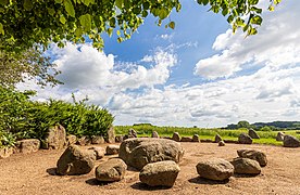
The Thingplatz in Gulde
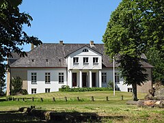
Gut Drält, mansion
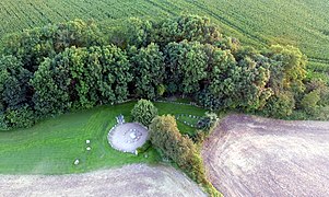
The Thingplatz in Gulde, aerial view


politics
Community representation
Since the local elections in 2018, the municipal council has consisted of nine members. The KWS voter community has five seats, the WAS voter community three seats and SSW one seat. Mayor is Jörg Struve from the Vogelsang district.
coat of arms
Blazon : “Divided diagonally left by silver and green. Above a linden leaf with a seed stand, below a scythe left with the leaf facing outwards, both figures in mixed up colors. "
economy
Stoltebüll is primarily characterized by agriculture. There are wind turbines in the southern area of the municipality. A biogas plant for generating electricity was built in the Stenneshöh district in 2007. There are also two IT companies in the community.
Attractions
The list of cultural monuments in Stoltebüll includes the cultural monuments entered in the list of monuments of Schleswig-Holstein.
Web links
Individual evidence
- ↑ North Statistics Office - Population of the municipalities in Schleswig-Holstein 4th quarter 2019 (XLSX file) (update based on the 2011 census) ( help on this ).
- ^ M. Mørk Hansen: Kirkelig Statistics over Slesvig Stift: Med historiske og topografiske bemærkninger , Kjøbenhavn 1864, Volume 2, Page 404
- ↑ Johannes Kok: Det danske folkesprog i Sønderjylland , Volume 2, København 1867, page 271
- ↑ Johannes Kok: Det danske folkesprog i Sønderjylland , Volume 2, København 1867, page 353
- ^ M. Mørk Hansen: Kirkelig Statistics over Slesvig Stift: Med historiske og topographiske Bemarkninger , Volume 2, p. 404
- ↑ Wolfgang Laur: Historisches Ortnamelexikon von Schleswig-Holstein , 2nd edition, Neumünster 1992, p. 624
- ↑ Wolfgang Laur: Historisches Ortnamelexikon von Schleswig-Holstein , 2nd edition, Neumünster 1992, p. 583
- ↑ Johannes Kok: Det danske folkesprog i Sønderjylland , Volume 2, København 1867, p. 355
- ↑ Wolfgang Laur: Historisches Ortsnamelexikon von Schleswig-Holstein , 2nd edition, Neumünster 1992, p. 705
- ↑ Wolfgang Laur: Historisches Ortsnamelexikon von Schleswig-Holstein , 2nd edition, Neumünster 1992, p. 584
- ↑ Johannes Kok: Det danske folkesprog i Sønderjylland , Volume 2, København 1867, p. 353
- ↑ Wolfgang Laur: Historisches Ortnamelexikon von Schleswig-Holstein , 2nd edition, Neumünster 1992, p. 221
- ↑ Johannes Kok: Det danske folkesprog i Sønderjylland , Volume 2, København 1867, p. 112
- ↑ Schleswig-Holstein's municipal coat of arms
Ahneby | Alt Bennebek | Arnis | Ausacker | Bergenhusen | Böel | Böklund | Bollingstedt | Bores | Borgwedel | Börm | Böxlund | Brodersby-Goltoft | Busdorf | Dannewerk | Dollerup | Dbodstedt | Eggebek | Ellingstedt | Invent | Esgrus | Fahrdorf | Free will | Gelting | Geltorf | Glücksburg (Baltic Sea) | Grödersby | Great Rheide | Großewiehe | Large voltage | Grundhof | Handewitt | Harrislee | Hasselberg | Havetoft | Hollingstedt | Holt | Hörup | Hürup | Husby | Hüsby | Idstedt | Jagel | Janneby | Jardelund | Jerrishoe | Jörl | Jübek | Kappeln | Folded wood | Klein Bennebek | Klein Rheide | Kronsgaard | Kropp | Long-crowned | Langstedt | Lindewitt | Loit | Lottorf | Lürschau | Maasbüll | Maasholm | Medelby | Meggerdorf | Meyn | Middle fishing | Mohrkirch | Munkbrarup | Neuberend | Nieby | Sneeze gray | Norderbrarup | Nordhackstedt | Nottfeld | Nübel | Oersberg | Oeversee | Osterby | Pommerby | Rabel | Raven wood | Rabenkirchen-Faulück | Ringsberg | Rügge | Saustrup | Schaalby | Schafflund | Scheggerott | Schleswig | Schnarup-Thumby | Schuby | Selk | Sieverstedt | Silberstedt | Sollerup | Soerup | Hatchback | Stack | Steinberg | Steinberg Church | Steinfeld | Sterup | Proud | Stoltebüll | Struxdorf | Süderbrarup | Süderfahrenstedt | Süderhackstedt | Taarstedt | Tarp | Tastrup | Tetenhusen | Tielen | Tolk | Treia | Twedt | Uelsby | Ulsnis | Wagersrott | Wallsbull | Wanderup | Wees | Weesby | Westerholz | Wohlde