
Hörup
| coat of arms | Germany map | |
|---|---|---|

|
Coordinates: 54 ° 44 ' N , 9 ° 6' E |
|
| Basic data | ||
| State : | Schleswig-Holstein | |
| Circle : | Schleswig-Flensburg | |
| Office : | Schafflund | |
| Height : | 5 m above sea level NHN | |
| Area : | 18.15 km 2 | |
| Residents: | 619 (Dec. 31, 2019) | |
| Population density : | 34 inhabitants per km 2 | |
| Postal code : | 24980 | |
| Area code : | 04639 | |
| License plate : | SL | |
| Community key : | 01 0 59 123 | |
| LOCODE : | DE 5HP | |
| Office administration address: | Tannenweg 1 24980 Schafflund |
|
| Website : | ||
| Mayor : | Peter Lorenz Greisen (KWGH) | |
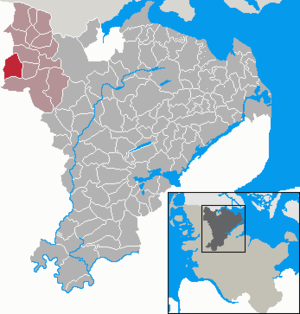
| Location of the municipality of Hörup in the Schleswig-Flensburg district | ||
  |
||

Hörup ( Danish : Hørup ) is a municipality in the Schleswig-Flensburg district in Schleswig-Holstein . Bärenshöft ( Bjørnshoved ), Neu-Hörup and Spölbek ( Spølbæk ) are in the municipality.
history
The place was first mentioned in 1472 as Horop ( place where there is plenty of hay ). Turf iron ore was mined southeast of the town until the beginning of the 20th century .
Hörup was recognized as a child, youth and family friendly community.
politics
Community representation
Of the nine seats in the municipal council has Wählergemeinschaft KWGH since the municipal election 2018 nine seats
coat of arms
Blazon : "In blue under three five-pointed golden stars in the position 1: 2 a golden wooden bridge supported on both sides by stone plinths, including eight golden wave crests in the position 2: 3: 3."
The district of Hörup is crossed by the water-rich Schafflunder Au and next to it by numerous small floodplains. These natural conditions, which were disadvantageous for smooth traffic connections, made it necessary to build bridges in the vicinity of the place at an early stage. In 1769 decreed King Christian VII . the construction of three bridges; today there are a total of eight crossings in the municipality. The main character of the coat of arms indicates the characteristic buildings, the number of which is indicated by the figure eight of the wave crests. The neighboring Spölbek has been incorporated into the village of Hörup since 1871, the year the community was founded, as have the Bärenshöft and Neu-Hörup residential areas. These three districts are represented by the three stars in the coat of arms. The blue color of the shield indicates the advantages and disadvantages of a water-rich region in which, on the one hand, the meadows are protected from drying out in summer and, on the other hand, it is not uncommon for floods to reach into the houses.
economy
The community is predominantly agricultural, with wind energy now also playing a major role.
Web links
Individual evidence
- ↑ North Statistics Office - Population of the municipalities in Schleswig-Holstein 4th quarter 2019 (XLSX file) (update based on the 2011 census) ( help on this ).
- ↑ Schleswig-Holstein topography. Vol. 5: Holt - Krokau . 1st edition Flying-Kiwi-Verl. Junge, Flensburg 2005, ISBN 978-3-926055-79-8 , pp. 39 ( dnb.de [accessed on July 18, 2020]).
- ↑ Schleswig-Holstein's municipal coat of arms
Ahneby | Alt Bennebek | Arnis | Ausacker | Bergenhusen | Böel | Böklund | Bollingstedt | Bores | Borgwedel | Börm | Böxlund | Brodersby-Goltoft | Busdorf | Dannewerk | Dollerup | Dbodstedt | Eggebek | Ellingstedt | Invent | Esgrus | Fahrdorf | Free will | Gelting | Geltorf | Glücksburg (Baltic Sea) | Grödersby | Great Rheide | Großewiehe | Large voltage | Grundhof | Handewitt | Harrislee | Hasselberg | Havetoft | Hollingstedt | Holt | Hörup | Hürup | Husby | Hüsby | Idstedt | Jagel | Janneby | Jardelund | Jerrishoe | Jörl | Jübek | Kappeln | Folded wood | Klein Bennebek | Klein Rheide | Kronsgaard | Kropp | Long-crowned | Langstedt | Lindewitt | Loit | Lottorf | Lürschau | Maasbüll | Maasholm | Medelby | Meggerdorf | Meyn | Middle fishing | Mohrkirch | Munkbrarup | Neuberend | Nieby | Sneeze gray | Norderbrarup | Nordhackstedt | Nottfeld | Nübel | Oersberg | Oeversee | Osterby | Pommerby | Rabel | Raven wood | Rabenkirchen-Faulück | Ringsberg | Rügge | Saustrup | Schaalby | Schafflund | Scheggerott | Schleswig | Schnarup-Thumby | Schuby | Selk | Sieverstedt | Silberstedt | Sollerup | Soerup | Hatchback | Stack | Steinberg | Steinberg Church | Steinfeld | Sterup | Proud | Stoltebüll | Struxdorf | Süderbrarup | Süderfahrenstedt | Süderhackstedt | Taarstedt | Tarp | Tastrup | Tetenhusen | Tielen | Tolk | Treia | Twedt | Uelsby | Ulsnis | Wagersrott | Wallsbull | Wanderup | Wees | Weesby | Westerholz | Wohlde