
Borgwedel
| coat of arms | Germany map | |
|---|---|---|

|
Coordinates: 54 ° 30 ' N , 9 ° 40' E |
|
| Basic data | ||
| State : | Schleswig-Holstein | |
| Circle : | Schleswig-Flensburg | |
| Office : | Haddeby | |
| Height : | 4 m above sea level NHN | |
| Area : | 9.96 km 2 | |
| Residents: | 685 (Dec. 31, 2019) | |
| Population density : | 69 inhabitants per km 2 | |
| Postal code : | 24857 | |
| Primaries : | 04621, 04354 | |
| License plate : | SL | |
| Community key : | 01 0 59 012 | |
| LOCODE : | DE 77B | |
| Office administration address: | Rendsburger Strasse 54c 24866 Busdorf |
|
| Website : | ||
| Mayor : | Holger White (ABW) | |
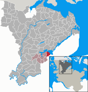
| Location of the municipality of Borgwedel in the Schleswig-Flensburg district | ||
  |
||

Borgwedel ( Danish : Borgvedel ) is a municipality in the Schleswig-Flensburg district in Schleswig-Holstein . It consists of the districts of Borgwedel and Stexwig ( Stegsvig ) and is located on the south bank of the Schlei around eight kilometers east of Schleswig . Other districts are Stexwigfeld, Borgwedelfeld and Osterlieth ( Østerlede ).
history

Names
The name Borgwedel is first documented in 1388. Around 1575/76 the name was mentioned in a document in the St. Johannis monastery archive . The part of the name -wedel refers either to the Old Norse veðill or vaðill for a fording or ford or is a later reinterpretation of wiek (Danish. Vig , old north. Vīk ) meaning settlement site. Accordingly, the name would be either the mudflat / ford belonging to a castle or settlement site / bay of a castle , although it is not possible to determine what is meant by castle, since the city of Schleswig is actually not called that.
The name of the second district, Stexwig, was first mentioned in 1412. The name is made up of dan. Bars for pole, post and tig (dan. vig ) for a bay. The name stands accordingly for pole or pile bay . This corresponds to the Palör (Reesholm) peninsula opposite the place, whose place name in Danish. pæle for stake goes back. According to another interpretation, the name stands for "bay and the water in front of the place".

Viking age fortification in the Schlei
More recently, during excavations in the Bay of Stexwig, defense systems from the Viking Age were discovered. First of all, numerous wooden beams were excavated when the Schlei was deepened in 1925. Investigations from the 1990s onwards revealed a 900 m long barrage between the Reesholm peninsula and a tip of the Kockbarg shoal excavated in 1925, consisting of square wooden structures with a side length of almost 5 m. The woods, besides oak also birch and willow, were felled in the winter of 737 so that an exact dating of the building is possible. The structure originally reached above the surface of the water and is also shown on old maps. The complex probably served as part of the Danewerk to protect the Viking settlement of Füsing .
politics
Community representation
Since the local elections in 2013, the SPD and the ABW electoral community each have four seats in the municipal council and the CDU two seats.
coat of arms
Blazon : "On gold, a raised, curved and clipped blue point at the top, covered with two rows of silver stakes following the arch, a silver mainsail with spinnaker at the bottom ."
Economy and Infrastructure
Borgwedel is a residential community with a strong focus on the district town of Schleswig . In the 1970s, several weekend home areas for Hamburgers were created. Agriculture has lost a lot of its importance in the past few decades. The nearest supermarket is in Fahrdorf, four kilometers away . The primary school for the Borgwedler children is also located there. Employers in the community are the youth hostel on the Schlei and two retirement homes .
Web links
Individual evidence
- ↑ North Statistics Office - Population of the municipalities in Schleswig-Holstein 4th quarter 2019 (XLSX file) (update based on the 2011 census) ( help on this ).
- ↑ Schleswig-Holstein topography. Vol. 2: Boren - Ellerau . 1st edition Flying-Kiwi-Verl. Junge, Flensburg 2002, ISBN 978-3-926055-68-2 , p. 15 ( dnb.de [accessed June 11, 2020]).
- ↑ Schleswig-Holstein topography. Vol. 2: Boren - Ellerau . 1st edition Flying-Kiwi-Verl. Junge, Flensburg 2002, ISBN 978-3-926055-68-2 , p. 15 ( dnb.de [accessed June 12, 2020]).
- ↑ Johannes Kok: Det danske folkesprog i Sønderjylland , Volume 2, København 1867, p. 91
- ↑ Wolfgang Laur: Historisches Ortsnamelexikon von Schleswig-Holstein , 2nd edition, Neumünster 1992, p. 195
- ↑ see also Wolfgang Laur , Historisches Ortsnamelexikon von Schleswig-Holstein
- ↑ Johannes Kok: Det danske folkesprog i Sønderjylland , Volume 2, København 1867, p. 304
- ^ Schleswig-Holsteinisches Landesarchiv, Urkundsabtl. 16.1.7, "De Villa Stexwyg"
- ↑ The Danewerk's sea barrier
- ↑ Jürgen Griese: Historic harbors on the inner loop
- ↑ Schleswig-Holstein's municipal coat of arms
Ahneby | Alt Bennebek | Arnis | Ausacker | Bergenhusen | Böel | Böklund | Bollingstedt | Bores | Borgwedel | Börm | Böxlund | Brodersby-Goltoft | Busdorf | Dannewerk | Dollerup | Dbodstedt | Eggebek | Ellingstedt | Invent | Esgrus | Fahrdorf | Free will | Gelting | Geltorf | Glücksburg (Baltic Sea) | Grödersby | Great Rheide | Großewiehe | Large voltage | Grundhof | Handewitt | Harrislee | Hasselberg | Havetoft | Hollingstedt | Holt | Hörup | Hürup | Husby | Hüsby | Idstedt | Jagel | Janneby | Jardelund | Jerrishoe | Jörl | Jübek | Kappeln | Folded wood | Klein Bennebek | Klein Rheide | Kronsgaard | Kropp | Long-crowned | Langstedt | Lindewitt | Loit | Lottorf | Lürschau | Maasbüll | Maasholm | Medelby | Meggerdorf | Meyn | Middle fishing | Mohrkirch | Munkbrarup | Neuberend | Nieby | Sneeze gray | Norderbrarup | Nordhackstedt | Nottfeld | Nübel | Oersberg | Oeversee | Osterby | Pommerby | Rabel | Raven wood | Rabenkirchen-Faulück | Ringsberg | Rügge | Saustrup | Schaalby | Schafflund | Scheggerott | Schleswig | Schnarup-Thumby | Schuby | Selk | Sieverstedt | Silberstedt | Sollerup | Soerup | Hatchback | Stack | Steinberg | Steinberg Church | Steinfeld | Sterup | Proud | Stoltebüll | Struxdorf | Süderbrarup | Süderfahrenstedt | Süderhackstedt | Taarstedt | Tarp | Tastrup | Tetenhusen | Tielen | Tolk | Treia | Twedt | Uelsby | Ulsnis | Wagersrott | Wallsbull | Wanderup | Wees | Weesby | Westerholz | Wohlde