
Nottfeld
| coat of arms | Germany map | |
|---|---|---|

|
Coordinates: 54 ° 37 ' N , 9 ° 46' E |
|
| Basic data | ||
| State : | Schleswig-Holstein | |
| Circle : | Schleswig-Flensburg | |
| Office : | Süderbrarup | |
| Height : | 32 m above sea level NHN | |
| Area : | 3.18 km 2 | |
| Residents: | 120 (Dec. 31, 2019) | |
| Population density : | 38 inhabitants per km 2 | |
| Postal code : | 24392 | |
| Area code : | 04641 | |
| License plate : | SL | |
| Community key : | 01 0 59 065 | |
| Office administration address: | Königstrasse 5 24392 Süderbrarup |
|
| Website : | ||
| Mayor : | Rainer Grünert (KWN) | |
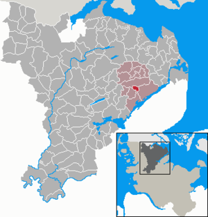
| Location of the municipality of Nottfeld in the Schleswig-Flensburg district | ||
  |
||

Nottfeld ( Danish : Notfeld ) is a municipality in the Schleswig-Flensburg district in Schleswig-Holstein . Breau ( Bredaa ), Kuhholz ( Koholt ), Niefeld ( Nyfeld ) and Nottfeld are in the municipality.
Geography and traffic
Nottfeld is located about 17 km northeast of Schleswig and 12 km southwest of Kappeln between the federal highway 201 from Husum to Kappeln and the Schlei .
history
The place name was first given in King Waldemar's Earth Book 1231 as Nutæ fellæ . In 1492 the form Nutvelde is found . The name goes back to the Old Danish nut (plural nutæ , Old Norse : hnot , New Danish: nød ) for nut and fella for field (cf. English field , West Germanic : felþa , Old Norse: fold or Old Norse fjall for highland) and describes a with Nut bushes overgrown field.
In 1787 the Danish King Christian VII built the “Christianslyst” hunting lodge in Nottfeld, which was under the Danish crown until 1864. It has been used by the Danish minority as a youth and training center since 1952 .
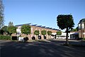
photos

Nottfeld fire station
Christianslyst youth and training center for the Danish minority
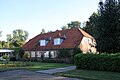
Christianslyst Hunting Lodge


politics
Since the municipal elections in 2013, the KWN voter community has all seven seats in the municipal council. She was able to repeat this result in 2018.
economy
The community is predominantly agricultural.
Attractions
The list of cultural monuments in Nottfeld includes the cultural monuments entered in the monuments list of Schleswig-Holstein.
Web links
Individual evidence
- ↑ North Statistics Office - Population of the municipalities in Schleswig-Holstein 4th quarter 2019 (XLSX file) (update based on the 2011 census) ( help on this ).
- ↑ Wolfgang Laur: Historisches Ortsnamelexikon von Schleswig-Holstein , 2nd edition, Neumünster 1992, p. 491
- ↑ Johannes Kok: Det danske folkesprog i Sønderjylland , Volume 2, Copenhagen 1867, p. 292
- ↑ Nottfeld municipal election 2018.verwaltungsportal.de , accessed on November 5, 2018 .
Ahneby | Alt Bennebek | Arnis | Ausacker | Bergenhusen | Böel | Böklund | Bollingstedt | Bores | Borgwedel | Börm | Böxlund | Brodersby-Goltoft | Busdorf | Dannewerk | Dollerup | Dbodstedt | Eggebek | Ellingstedt | Invent | Esgrus | Fahrdorf | Free will | Gelting | Geltorf | Glücksburg (Baltic Sea) | Grödersby | Great Rheide | Großewiehe | Large voltage | Grundhof | Handewitt | Harrislee | Hasselberg | Havetoft | Hollingstedt | Holt | Hörup | Hürup | Husby | Hüsby | Idstedt | Jagel | Janneby | Jardelund | Jerrishoe | Jörl | Jübek | Kappeln | Folded wood | Klein Bennebek | Klein Rheide | Kronsgaard | Kropp | Long-crowned | Langstedt | Lindewitt | Loit | Lottorf | Lürschau | Maasbüll | Maasholm | Medelby | Meggerdorf | Meyn | Middle fishing | Mohrkirch | Munkbrarup | Neuberend | Nieby | Sneeze gray | Norderbrarup | Nordhackstedt | Nottfeld | Nübel | Oersberg | Oeversee | Osterby | Pommerby | Rabel | Raven wood | Rabenkirchen-Faulück | Ringsberg | Rügge | Saustrup | Schaalby | Schafflund | Scheggerott | Schleswig | Schnarup-Thumby | Schuby | Selk | Sieverstedt | Silberstedt | Sollerup | Soerup | Hatchback | Stack | Steinberg | Steinberg Church | Steinfeld | Sterup | Proud | Stoltebüll | Struxdorf | Süderbrarup | Süderfahrenstedt | Süderhackstedt | Taarstedt | Tarp | Tastrup | Tetenhusen | Tielen | Tolk | Treia | Twedt | Uelsby | Ulsnis | Wagersrott | Wallsbull | Wanderup | Wees | Weesby | Westerholz | Wohlde