
Jörl
| coat of arms | Germany map | |
|---|---|---|

|
Coordinates: 54 ° 37 ' N , 9 ° 16' E |
|
| Basic data | ||
| State : | Schleswig-Holstein | |
| Circle : | Schleswig-Flensburg | |
| Office : | Eggebek | |
| Height : | 23 m above sea level NHN | |
| Area : | 19.68 km 2 | |
| Residents: | 736 (Dec. 31, 2019) | |
| Population density : | 37 inhabitants per km 2 | |
| Postal code : | 24992 | |
| Area code : | 04607 | |
| License plate : | SL | |
| Community key : | 01 0 59 132 | |
| Office administration address: | Hauptstrasse 2 24852 Eggebek |
|
| Website : | ||
| Mayor : | Thomas Peter Kahlund (KWJ) | |
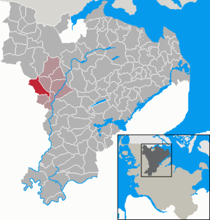
| Location of the municipality Jörl in the Schleswig-Flensburg district | ||
  |
||

Jörl ( Danish : Jørl , also Hjørdel ) is a municipality in the Schleswig-Flensburg district in Schleswig-Holstein .
geography
Geographical location
The municipality of Jörl is located in the middle of the Niedere Geest in the west of the Schleswig-Flensburg district . The area is part of the Schleswig Geest . The main body of water within the municipality is the Jörlau , a left-hand tributary of the Ostenau , which drains over the Arlau into the North Sea. The only slightly inclined landscape relief of ground moraines is characteristic of this area . These so-called sand areas were created by the flowing glacier water at the end of the Vistula Ice Age .
Community structure
Großjörl ( Store Jørl ), Kleinjörl ( Lille Jørl ), Paulsgabe ( Povlsgab ), Rimmelsberg ( Rimmelsbjerg ), Rupel ( Rubøl or Rugbøl ), Stieglund ( Stiglund ) and Südermoor are located in the municipality.
Neighboring communities
Jörl borders on:
| Lindewitt | Grown up | Janneby |
| Löwenstedt |
.svg)
|
|
| Sollwitt | Süderhackstedt | Sollerup |
history
The place was first mentioned in 1240 as Jorlum , in 1462 the form Iorle is found . In the 18th century Den Danske Atlas it is called Jordel . The name goes back to the old Danish form iørul (corresponding to Old Norse jǫrvi ) and means grus, height of sand . Rupel (Danish Rubøl ) could go back to the Old Norse animal name hrútr for ram, to the nickname Ruki or to North Frisian Ruuke for pile of sand. The ending -pel corresponds to the Danish ending -bøl , dt. -Büll . The name Rimmelsberg comes from Danish. rimme (altn. rimi ) for a row of dunes or a ridge back.
The St. Katharinen Church was built in the 14th century. The bell tower from 1914 replaced an older tower that was separate from the church. Until the German-Danish War Jörl formed the center of the parish Jörl (Danish Jørl Sogn or Hjørdel Sogn ) within the Uggelharde .
From 1889 to 1968 Jörl was the seat of the administration of the district or the office of Jörl. Since its dissolution, Jörl has belonged to the Eggebek office .
politics
Community representation
All nine members of the community council have belonged to the KWJ voter community since the local elections in 2018 .
coat of arms
Blazon : "In gold, a three-part green juniper branch with seven black fruits (berries)."
The coat of arms indicates the nature reserve Rimmelsberg, where there are a large number of juniper bushes. The seven berries are supposed to represent the districts.
Culture and sights
In the list of cultural monuments in Jörl are the cultural monuments entered in the monuments list of the state of Schleswig-Holstein.
The Pobüller Bauernwald and the inland dune on the Rimmelsberg are designated nature reserves .
Economy and Infrastructure
The community is predominantly agricultural, with the dairy industry predominating.
Web links
Individual evidence
- ↑ North Statistics Office - Population of the municipalities in Schleswig-Holstein 4th quarter 2019 (XLSX file) (update based on the 2011 census) ( help on this ).
- ↑ John Kousgård Sørensen: Danske Sø- og ånavne: T-Å , Akademisk Forlag 1989, p 108
- ↑ Foreningen Danmarks folkeminder: Danmarks folkeminder 67 , 1957, page 184
- ↑ Johannes Kok: Det danske folkesprog i Sønderjylland , Volume 2, Copenhagen 1867, p. 325
- ^ Housing directory Schleswig-Holstein 1987. (pdf) State Statistical Office Schleswig-Holstein, accessed on February 3, 2019 .
- ↑ Wolfgang Laur: Historisches Ortnamelexikon von Schleswig-Holstein , 2nd edition, Neumünster 1992, p. 365
- ↑ Anders Bjerrum, Kristian Hald, Peter Jørgensen: Sydslesvigs stednavne , Volume 7, Copenhagen 1948, p. 69
- ↑ Wolfgang Laur: Historisches Ortnamelexikon von Schleswig-Holstein , 2nd edition, Neumünster 1992, p. 365
- ↑ Anders Bjerrum: Sydslesvigs stednavne , Volume 4, Copenhagen 1979–1984, p. 410
- ↑ Schleswig-Holstein's municipal coat of arms
Ahneby | Alt Bennebek | Arnis | Ausacker | Bergenhusen | Böel | Böklund | Bollingstedt | Bores | Borgwedel | Börm | Böxlund | Brodersby-Goltoft | Busdorf | Dannewerk | Dollerup | Dbodstedt | Eggebek | Ellingstedt | Invent | Esgrus | Fahrdorf | Free will | Gelting | Geltorf | Glücksburg (Baltic Sea) | Grödersby | Great Rheide | Großewiehe | Large voltage | Grundhof | Handewitt | Harrislee | Hasselberg | Havetoft | Hollingstedt | Holt | Hörup | Hürup | Husby | Hüsby | Idstedt | Jagel | Janneby | Jardelund | Jerrishoe | Jörl | Jübek | Kappeln | Folded wood | Klein Bennebek | Klein Rheide | Kronsgaard | Kropp | Long-crowned | Langstedt | Lindewitt | Loit | Lottorf | Lürschau | Maasbüll | Maasholm | Medelby | Meggerdorf | Meyn | Middle fishing | Mohrkirch | Munkbrarup | Neuberend | Nieby | Sneeze gray | Norderbrarup | Nordhackstedt | Nottfeld | Nübel | Oersberg | Oeversee | Osterby | Pommerby | Rabel | Raven wood | Rabenkirchen-Faulück | Ringsberg | Rügge | Saustrup | Schaalby | Schafflund | Scheggerott | Schleswig | Schnarup-Thumby | Schuby | Selk | Sieverstedt | Silberstedt | Sollerup | Soerup | Hatchback | Stack | Steinberg | Steinberg Church | Steinfeld | Sterup | Proud | Stoltebüll | Struxdorf | Süderbrarup | Süderfahrenstedt | Süderhackstedt | Taarstedt | Tarp | Tastrup | Tetenhusen | Tielen | Tolk | Treia | Twedt | Uelsby | Ulsnis | Wagersrott | Wallsbull | Wanderup | Wees | Weesby | Westerholz | Wohlde