Maasbull
| coat of arms | Germany map | |
|---|---|---|

|
Coordinates: 54 ° 47 ' N , 9 ° 31' E |
|
| Basic data | ||
| State : | Schleswig-Holstein | |
| Circle : | Schleswig-Flensburg | |
| Office : | Hürup | |
| Height : | 58 m above sea level NHN | |
| Area : | 7.71 km 2 | |
| Residents: | 697 (Dec. 31, 2019) | |
| Population density : | 90 inhabitants per km 2 | |
| Postal code : | 24975 | |
| Area code : | 04634 | |
| License plate : | SL | |
| Community key : | 01 0 59 141 | |
| LOCODE : | DE MB3 | |
| Office administration address: | Schulstrasse 1 24975 Hürup |
|
| Website : | ||
| Mayor : | Hans-Georg Hinrichsen (KWG) | |
| Location of the municipality of Maasbüll in the Schleswig-Flensburg district | ||
Maasbüll ( Danish : Masbøl ) is a municipality in the Schleswig-Flensburg district in Schleswig-Holstein . Krim, Maasbüllfeld, Maasbüllhof ( Masbølgård ), Maasbüllmoor, Neukrug ( Nykro ), Ruhnmark ( Runmark ) and Rüllschau ( Rylskov ) are in the municipality.
location
To the north of Maasbüll is Flensburg's suburb Wees , which borders on the Mürwik district . To the west of Maasbüll are the districts of Engelsby and Tarup . Due to its proximity to Flensburg, Maasbüll is considered a rural suburb of the city, even if the village has not grown into Flensburg. To the northeast is Munkbrarup , which has historically grown together with Glücksburg and, together with it, is also a candidate for incorporation into the city. To the east lies Husby and to the south of the municipality is Hürup .
history
Grave fields from the Bronze Age have been preserved in the municipality , and there are also some Stone Age barrows .
The Michaeliskirche in Rüllschau was built in the 13th century on a pre-Christian cult site. Before the tower was built in 1779, the wooden bell tower stood across the street. The Protestant parish of Rüllschau includes the entire current political community of Maasbüll, but the small parish has shared the pastor with Hürup since 1958 .
Rüllschau (Danish Rylskov ) was first mentioned around 1430 as Rolschouw and means forest of Rolf , going back to Danish. skov for forest and the nickname Rolf. An interpretation of the southern Jutland form rylle for hornbeam is also possible . Maasbüll was first mentioned in 1445 as Masbul ( settlement on the moor ).
The Landgasthof Neukrug ( Nykro ) on the old Flensburg-Kappelner Chaussee, which is still in operation today, was founded in 1752, the current building was erected in 1911.
In 1965 the previously independent rural communities of Rüllschau and Maasbüll merged to form the municipality of Rüllschau-Maasbüll. Although Rüllschau was historically more important as a church village, the name of the somewhat larger southern village, which also had a rail connection and better road connections, became the sole name of the community in 1969.
Since around 2015, Flensburg has been so densely populated that it is no longer possible to create new living space there. The growth of the city and the surrounding area is inhibited and the issue of incorporation therefore plays a role again.
politics
Community representation
Of the eleven seats in the municipal council has the Wählergemeinschaft KWG since the local elections in 2013 five seats, the CDU , the SPD and SSW have two seats each.
coat of arms
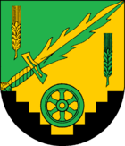
Blazon : "Over black Sturzgiebelschildfuß - about a resting green wagon wheel - green and gold with a flaming sword in confused colors divided diagonally left. Upper right a golden ear, lower left a green ear. "
economy
In the Maasbüll district in particular, there are not only supraregional businesses, but also extensive residential areas.
traffic
In 1881 a train station was built on the Kiel – Flensburg railway in Maasbüll, which gave the community an economic boom. In 1980 the station was closed. State road 21 creates a cross connection from federal road 199 in Flensburg via Maasbüll to federal road 199 in Kappeln .
Attractions
The list of cultural monuments in Maasbüll includes the cultural monuments entered in the monuments list of Schleswig-Holstein.
You can hike over a field path from the nearby Rüllschau, over the Vogelsang to Trögelsby and so to Flensburg .
Web links
Individual evidence
- ↑ North Statistics Office - Population of the municipalities in Schleswig-Holstein 4th quarter 2019 (XLSX file) (update based on the 2011 census) ( help on this ).
- ^ Wolfgang Laur: Historical place-name dictionary of Schleswig-Holstein. 2nd edition, Neumünster 1992, p. 556
- ^ Johannes Kok: Det Danske folkesprog i Sønderjylland. Volume 2, Copenhagen 1867, p. 327
- ↑ Flensburger Tageblatt : Housing Contingents: City-Surrounding-Peace Before the End , from: June 4, 2015; Retrieved on: June 4, 2015
- ↑ Schleswig-Holstein's municipal coat of arms


