
Selk
| coat of arms | Germany map | |
|---|---|---|

|
Coordinates: 54 ° 28 ' N , 9 ° 34' E |
|
| Basic data | ||
| State : | Schleswig-Holstein | |
| Circle : | Schleswig-Flensburg | |
| Office : | Haddeby | |
| Height : | 19 m above sea level NHN | |
| Area : | 10.07 km 2 | |
| Residents: | 866 (Dec. 31, 2019) | |
| Population density : | 86 inhabitants per km 2 | |
| Postal code : | 24884 | |
| Area code : | 04621 | |
| License plate : | SL | |
| Community key : | 01 0 59 078 | |
| Office administration address: | Rendsburger Strasse 54c 24866 Busdorf |
|
| Website : | ||
| Mayor : | Thilo Kolberg (AWGS) | |
| Location of the municipality of Selk in the Schleswig-Flensburg district | ||
  |
||

Selk is a municipality in the Schleswig-Flensburg district in Schleswig-Holstein.
Geography and traffic

Selk is located directly south of Schleswig on the Selker Noor der Schlei . To the west, the federal highway 7 runs from Rendsburg to Schleswig, to the north, the federal highway 76 from Eckernförde to Schleswig.
history
The place name is derived from the Danish word selje (willow). The first documentary mention was on March 5, 1412. The then Schleswig bishop asked the community of Selk to pay their church taxes.
Selk is divided into the districts Oberselk ( Danish Ovre Selk or Over Selk ), Niederselk ( Nedre Selk or Neder Selk ), Wedelspang ( Vedelspang ) and Altmühl. While Oberselk historically belonged to the Gottorf office and was therefore subordinate to the Duke of Schleswig-Holstein-Gottorf , Niederselk originally belonged to the St. Johannis Monastery outside Schleswig . The districts were united in the 1930s. Today Selk belongs to the Haddeby office .
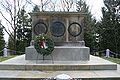
King hill
A battle between Viking kings is said to have taken place in the municipality in 872 . As a result, many barrows and barrows can still be found in Selk today. Sigurd is said to have been buried under the 42 m high King's Hill.
This royal hill at the entrance to Selk is also a memorial to the fallen Austrian soldiers in the German-Danish War of 1864. In and around Selk there are also graves of fallen soldiers from Austria, Prussia and Denmark scattered across the fields and along the paths (see Battle of the King's Hill ).
Kograben
The Kograben (Danish: Kovirke) ends in Selk . It is part of the Danewerk wall systems and is located 1 to 2 km south of the Danewerk near Schleswig. It stretches in a straight line from the Rheider Au near Kurburg to the Selker Noor on the Schlei. The facility consisted of a 2 m high and 7 m wide embankment, which was preceded by a 4 m wide and 3 m deep pointed ditch. The embankment of the earth wall was provided with a wooden palisade on the side facing the pointed ditch, which was secured by inclined support pillars. The time of origin of the Kograben is difficult to date. Recent studies suggest that it was built around the year 800. According to this, the Kograben is equated with the Göttrikswall built by Gudfred in 808 against the Frankish empire of Charlemagne. The special palisade technique, however, is similar to the technique that was used in the Danish ring castles, which were only built around the year 980. It is unclear whether the Kograben was also or instead part of the shipping route between the North and Baltic Seas. In the early Middle Ages, shipping used the route via Eider - Treene - Rheider Au - Schlei to avoid the dangerous circumnavigation of Jutland. A developed lock technology for that time or before is only documented for the Tumilat Canal in distant Egypt. On the other hand, there is also the possibility that the ships from the Selker Noor to the watershed (1 km distance with 25 m difference in altitude) were pulled on dry land, but on the much longer section between the watershed and Rheider Au, but effortlessly on the water of the Kograben.
politics
Community representation
Since the local elections in 2013, all eleven members of the municipal council include the voter community of AWGs.
coat of arms
Blazon : "Divided by gold and blue obliquely to the left, above a green pollarded willow, below a slanted eight-spoke silver mill wheel below."
economy
Residential use predominates in the center, while the outskirts are predominantly agricultural.
Attractions
The list of cultural monuments in Selk includes the cultural monuments entered in the list of monuments of Schleswig-Holstein.
Sports
The TSV Selk reached his table tennis department in the 1978/79 Bundesliga , but had not won immediately go back.
The football club FC Altmühl 09 was founded in 2009.
Sons and daughters
- Andreas Grüning (born September 28, 1756 in Selker Mühle, † 1821 in Ottensen), educator and calligrapher
photos
- Königshügel memorial

blackboard

Front
right side

Left side


literature
- Lutz Mohr : The "Erik stone" from Wedelspang near Schleswig and the Schleswig "Domstein" - two runological testimonies to warlike and peaceful Vikingism . Rainer H. Schmeissner (Ed.): In: Steinkreuzforschung (SKF). Studies on German and international land monument research (series of monographs), No. 10, Regensburg 1999, pp. 23–32
- Johannes von Schröder: Topography of the Duchy of Schleswig . Leipzig 1854
Web links
Individual evidence
- ↑ North Statistics Office - Population of the municipalities in Schleswig-Holstein 4th quarter 2019 (XLSX file) (update based on the 2011 census) ( help on this ).
- ↑ Schleswig-Holstein topography. Vol. 9: Schönberg - Tielenhemme . 1st edition Flying-Kiwi-Verl. Junge, Flensburg 2007, ISBN 978-3-926055-91-0 , p. 92 ( dnb.de [accessed on July 31, 2020]).
- ↑ Topographic map 1: 50,000
- ↑ Schleswig-Holstein's municipal coat of arms
Ahneby | Alt Bennebek | Arnis | Ausacker | Bergenhusen | Böel | Böklund | Bollingstedt | Bores | Borgwedel | Börm | Böxlund | Brodersby-Goltoft | Busdorf | Dannewerk | Dollerup | Dbodstedt | Eggebek | Ellingstedt | Invent | Esgrus | Fahrdorf | Free will | Gelting | Geltorf | Glücksburg (Baltic Sea) | Grödersby | Great Rheide | Großewiehe | Large voltage | Grundhof | Handewitt | Harrislee | Hasselberg | Havetoft | Hollingstedt | Holt | Hörup | Hürup | Husby | Hüsby | Idstedt | Jagel | Janneby | Jardelund | Jerrishoe | Jörl | Jübek | Kappeln | Folded wood | Klein Bennebek | Klein Rheide | Kronsgaard | Kropp | Long-crowned | Langstedt | Lindewitt | Loit | Lottorf | Lürschau | Maasbüll | Maasholm | Medelby | Meggerdorf | Meyn | Middle fishing | Mohrkirch | Munkbrarup | Neuberend | Nieby | Sneeze gray | Norderbrarup | Nordhackstedt | Nottfeld | Nübel | Oersberg | Oeversee | Osterby | Pommerby | Rabel | Raven wood | Rabenkirchen-Faulück | Ringsberg | Rügge | Saustrup | Schaalby | Schafflund | Scheggerott | Schleswig | Schnarup-Thumby | Schuby | Selk | Sieverstedt | Silberstedt | Sollerup | Soerup | Hatchback | Stack | Steinberg | Steinberg Church | Steinfeld | Sterup | Proud | Stoltebüll | Struxdorf | Süderbrarup | Süderfahrenstedt | Süderhackstedt | Taarstedt | Tarp | Tastrup | Tetenhusen | Tielen | Tolk | Treia | Twedt | Uelsby | Ulsnis | Wagersrott | Wallsbull | Wanderup | Wees | Weesby | Westerholz | Wohlde