
Old Bennebek
| coat of arms | Germany map | |
|---|---|---|

|
Coordinates: 54 ° 23 ' N , 9 ° 26' E |
|
| Basic data | ||
| State : | Schleswig-Holstein | |
| Circle : | Schleswig-Flensburg | |
| Office : | Kropp stacking bar | |
| Height : | 2 m above sea level NHN | |
| Area : | 14.09 km 2 | |
| Residents: | 329 (Dec. 31, 2019) | |
| Population density : | 23 inhabitants per km 2 | |
| Postal code : | 24848 | |
| Area code : | 04624 | |
| License plate : | SL | |
| Community key : | 01 0 59 001 | |
| LOCODE : | DE 3AC | |
| Office administration address: | Am Markt 10 24848 Kropp |
|
| Website : | ||
| Mayor : | Hans-Detlef Gehre (KWG) | |
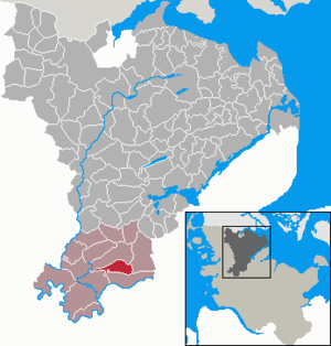
| Location of the community Alt Bennebek in the Schleswig-Flensburg district | ||
  |
||

Alt Bennebek ( Danish : Gammel Bennebæk) is a municipality in the Schleswig-Flensburg district in Schleswig-Holstein . Diversion dike and Sprillbick are in the municipality.
Geography and traffic
Alt Bennebek is located about 30 km northwest of Rendsburg in the Sorge lowlands on the border between Geest and Marsch . The federal highway 77 runs about 15 km east and the federal highway 7 runs from Rendsburg to Schleswig about 30 km east .
history
The place was first mentioned in a document around 1340 as villa Bennebeke (surrounded by streams) .
In the municipality, peat was extracted from the Tetenhusener Moor as fuel.
politics
Community representation
Since the local elections in 2008 and 2013, the KWG electoral community has all nine seats in the municipal council.
coat of arms
Blazon : "A red peat spade and a red peat cutter (peat crockery) crossed diagonally in gold between two blue wavy bars, accompanied on both sides by an upright green oak leaf."
The two wave beams point to the streams . The oak leaves , which symbolize the cleared mixed oak forests in the coat of arms, are a reminder of the early settlers . The peat dishes make it clear that the bogs for peat extraction as fuel and economic material were of great importance for the community for a long time. The yellow shield refers to the sandy areas of the Schleswiger Vorgeest, on the southern edge of which the municipality is located.
economy
The community is predominantly agricultural.
Web links
Individual evidence
- ↑ North Statistics Office - Population of the municipalities in Schleswig-Holstein 4th quarter 2019 (XLSX file) (update based on the 2011 census) ( help on this ).
- ↑ Aasbüttel - Bordesholm . In: Wolfgang Henze (ed.): Schleswig-Holstein topography: cities and villages of the country . 1st edition. tape 1 . Flying-Kiwi-Verl. Junge, Flensburg 2001, ISBN 3-926055-58-8 , p. 64 .
- ↑ Schleswig-Holstein's municipal coat of arms
Ahneby | Alt Bennebek | Arnis | Ausacker | Bergenhusen | Böel | Böklund | Bollingstedt | Bores | Borgwedel | Börm | Böxlund | Brodersby-Goltoft | Busdorf | Dannewerk | Dollerup | Dbodstedt | Eggebek | Ellingstedt | Invent | Esgrus | Fahrdorf | Free will | Gelting | Geltorf | Glücksburg (Baltic Sea) | Grödersby | Great Rheide | Großewiehe | Large voltage | Grundhof | Handewitt | Harrislee | Hasselberg | Havetoft | Hollingstedt | Holt | Hörup | Hürup | Husby | Hüsby | Idstedt | Jagel | Janneby | Jardelund | Jerrishoe | Jörl | Jübek | Kappeln | Folded wood | Klein Bennebek | Klein Rheide | Kronsgaard | Kropp | Long-crowned | Langstedt | Lindewitt | Loit | Lottorf | Lürschau | Maasbüll | Maasholm | Medelby | Meggerdorf | Meyn | Middle fishing | Mohrkirch | Munkbrarup | Neuberend | Nieby | Sneeze gray | Norderbrarup | Nordhackstedt | Nottfeld | Nübel | Oersberg | Oeversee | Osterby | Pommerby | Rabel | Raven wood | Rabenkirchen-Faulück | Ringsberg | Rügge | Saustrup | Schaalby | Schafflund | Scheggerott | Schleswig | Schnarup-Thumby | Schuby | Selk | Sieverstedt | Silberstedt | Sollerup | Soerup | Hatchback | Stack | Steinberg | Steinberg Church | Steinfeld | Sterup | Proud | Stoltebüll | Struxdorf | Süderbrarup | Süderfahrenstedt | Süderhackstedt | Taarstedt | Tarp | Tastrup | Tetenhusen | Tielen | Tolk | Treia | Twedt | Uelsby | Ulsnis | Wagersrott | Wallsbull | Wanderup | Wees | Weesby | Westerholz | Wohlde