
Jerrishoe
| coat of arms | Germany map | |
|---|---|---|

|
Coordinates: 54 ° 40 ′ N , 9 ° 22 ′ E |
|
| Basic data | ||
| State : | Schleswig-Holstein | |
| Circle : | Schleswig-Flensburg | |
| Office : | Eggebek | |
| Height : | 20 m above sea level NHN | |
| Area : | 16 km 2 | |
| Residents: | 960 (Dec. 31, 2019) | |
| Population density : | 60 inhabitants per km 2 | |
| Postal code : | 24963 | |
| Area code : | 04638 | |
| License plate : | SL | |
| Community key : | 01 0 59 131 | |
| Office administration address: | Hauptstrasse 2 24852 Eggebek |
|
| Website : | ||
| Mayoress : | Heike Schmidt (AWGJ) | |
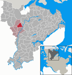
| Location of the municipality of Jerrishoe in the Schleswig-Flensburg district | ||
  |
||

Jerrishoe ( Danish : Jerrishøj ) is a municipality in the Schleswig-Flensburg district in Schleswig-Holstein . Jerrishoefeld ( Jerrishøjmark ) is located in the municipality.
history
The place Jerrishoe was first mentioned in 1196 as Erijshogh . The place name is composed of the personal name Jerrik ( Old Norse Eiríkr ) and hoe for hill (Danish høj ). According to another interpretation, the name is composed of the Danish words jern (iron), ris (bush) and høj ( barrow ). In the extensive oak forests of the region, iron was extracted from lawn iron ore for centuries , which can still be seen today in piles of slag and remains of smelting furnaces.
The Jerrishoe Coin Find
The coin find in Jerrishoe occurred in the late 19th or early 20th century. The exact year can no longer be clearly determined. The find was made by three workers when they were digging a trench in Jerrishoer Holzung. A strong oak was in line and had to be cleared. Under the root area close to the trunk, at a depth of one and a half to two meters, there was a heap of 55 silver coins . The owner of the property took the coins and sold all but four of them to a merchant from Bad Oldesloe . At the beginning of the Second World War these coins were still in the merchant's possession, after which there are no records of the whereabouts of the coins. The remaining four coins were still in the possession of a Jerrisho family in the 1930s.
politics
Community representation
Of the eleven seats in the municipal council, since the last local elections in 2018, the constituency AWGJ has six seats, the CDU four seats and one seat goes to an impartial person.
coat of arms
Blazon : “Divided obliquely by blue and gold on the left. Above a left-facing silver anvil, below a green oak branch consisting of four leaves and a fruit cluster. "
The anvil in the coat of arms stands for the earlier importance of iron extraction and processing for the place. The oak branch represents the forest and the original landscape of the municipality. Blue and yellow are the colors of the Duchy of Schleswig .
economy
The community is predominantly agricultural, with dairy farming being the most important branch of the agricultural industry. Some small to larger traders and a gravel pit are also located in the municipality.
For a few years now there has also been a community wind farm in Jerrishoe in the northern municipality
Web links
Individual evidence
- ↑ North Statistics Office - Population of the municipalities in Schleswig-Holstein 4th quarter 2019 (XLSX file) (update based on the 2011 census) ( help on this ).
- ↑ Schleswig-Holstein topography. Vol. 5: Holt - Krokau . 1st edition Flying-Kiwi-Verl. Junge, Flensburg 2005, ISBN 978-3-926055-79-8 , pp. 114 ( dnb.de [accessed July 19, 2020]).
- ↑ Wolfgang Laur: Historisches Ortsnamelexikon von Schleswig-Holstein , 2nd edition, Neumünster 1992, p. 364
- ↑ Schleswig-Holstein's municipal coat of arms
Ahneby | Alt Bennebek | Arnis | Ausacker | Bergenhusen | Böel | Böklund | Bollingstedt | Bores | Borgwedel | Börm | Böxlund | Brodersby-Goltoft | Busdorf | Dannewerk | Dollerup | Dbodstedt | Eggebek | Ellingstedt | Invent | Esgrus | Fahrdorf | Free will | Gelting | Geltorf | Glücksburg (Baltic Sea) | Grödersby | Great Rheide | Großewiehe | Large voltage | Grundhof | Handewitt | Harrislee | Hasselberg | Havetoft | Hollingstedt | Holt | Hörup | Hürup | Husby | Hüsby | Idstedt | Jagel | Janneby | Jardelund | Jerrishoe | Jörl | Jübek | Kappeln | Folded wood | Klein Bennebek | Klein Rheide | Kronsgaard | Kropp | Long-crowned | Langstedt | Lindewitt | Loit | Lottorf | Lürschau | Maasbüll | Maasholm | Medelby | Meggerdorf | Meyn | Middle fishing | Mohrkirch | Munkbrarup | Neuberend | Nieby | Sneeze gray | Norderbrarup | Nordhackstedt | Nottfeld | Nübel | Oersberg | Oeversee | Osterby | Pommerby | Rabel | Raven wood | Rabenkirchen-Faulück | Ringsberg | Rügge | Saustrup | Schaalby | Schafflund | Scheggerott | Schleswig | Schnarup-Thumby | Schuby | Selk | Sieverstedt | Silberstedt | Sollerup | Soerup | Hatchback | Stack | Steinberg | Steinberg Church | Steinfeld | Sterup | Proud | Stoltebüll | Struxdorf | Süderbrarup | Süderfahrenstedt | Süderhackstedt | Taarstedt | Tarp | Tastrup | Tetenhusen | Tielen | Tolk | Treia | Twedt | Uelsby | Ulsnis | Wagersrott | Wallsbull | Wanderup | Wees | Weesby | Westerholz | Wohlde