Havetoft
| coat of arms | Germany map | |
|---|---|---|

|
Coordinates: 54 ° 39 ' N , 9 ° 31' E |
|
| Basic data | ||
| State : | Schleswig-Holstein | |
| Circle : | Schleswig-Flensburg | |
| Office : | South fishing | |
| Height : | 39 m above sea level NHN | |
| Area : | 14.53 km 2 | |
| Residents: | 889 (Dec. 31, 2019) | |
| Population density : | 61 inhabitants per km 2 | |
| Postal code : | 24873 | |
| Area code : | 04603 | |
| License plate : | SL | |
| Community key : | 01 0 59 037 | |
| Office administration address: | Alte Dorfstrasse 38 24894 Tolk |
|
| Website : | ||
| Mayor : | Peter Hermann Petersen (nuclear power plant) | |
| Location of the municipality Havetoft in the Schleswig-Flensburg district | ||
Havetoft is a municipality in the Schleswig-Flensburg district in Schleswig-Holstein . Bunsbüllstraße, Havetoft, Havetoftfeld, Holming, Holmingfeld, Hostrup, Hostrupfeld, Hostrupholz (Danish: Hostrupskov ), Kroxbüll ( Krogsbøl ), Neuheim, Neuhof ( Nygård ), Osterhavetoft and Süderhavetoft are in the municipality.
geography
The community is located on Lake Havetofter , which also has a water mill .
history
The place was first mentioned in 1302. The place name means settlement with small fenced pieces of land .
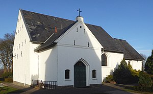
St. Mary's Church, built of granite blocks and field stones , was built in the 12th century. The separate wooden bell stack was built in 1763.
Incorporations
On February 1, 1974, the municipality of Hostrup was incorporated.
politics
Community representation
Of the eleven seats in the municipal council, the AKW electoral community has had six seats since the 2013 local elections, the SSW has three and the CDU has two.
coat of arms
Blazon : “Divided by silver and gold by a red oblique wave bar. Above a red horse's head with a silver blaze and below a red rear gate. "
The municipality Havetoft consists of the districts Havetoft and Hostrup. Until the 1950s they were purely farming villages, in which the horse was predominantly used as a draft animal on the farms. The name of the district Hostrup (host = Hors = horse) also refers to the horse, so that a horse's head was chosen for the coat of arms. The rear gate, entrance to a fenced-in field, stands for the name part of the Havetoft district (Have = enclosure). The wave bar is reminiscent of the Bollingstedter Au, which separates the districts.
economy
The municipal area is predominantly agricultural, but there are also purely residential areas.
Attractions
Parish
The Havetoft parish includes the political community Havetoft as well as the Klappholz and Havetoftloit parishes and has around 1600 parishioners. It belongs to the church region "Angling North-West".
Elisabethheim
The Elisabethheim , founded as an orphanage by Pastor Johannes Witt in 1888 , is a curative educational child and youth welfare facility that looks after around 60 children. It was named after the daughter Elisabeth Witt, who died in 1885 and who was very committed to helping orphans in the region.
literature
- Johannes Thomsen: Local history around St. Marien Havetoft. In: Yearbook of the Angler Heimatverein. 33: 109-115 (1969).
Web links
Individual evidence
- ↑ North Statistics Office - Population of the municipalities in Schleswig-Holstein 4th quarter 2019 (XLSX file) (update based on the 2011 census) ( help on this ).
- ↑ Schleswig-Holstein topography. Vol. 4: Groß Sarau - Holstenniendorf . 1st edition Flying-Kiwi-Verl. Junge, Flensburg 2004, ISBN 978-3-926055-75-0 , p. 171 ( dnb.de [accessed on May 3, 2020]).
- ^ Federal Statistical Office (ed.): Historical municipality directory for the Federal Republic of Germany. Name, border and key number changes in municipalities, counties and administrative districts from May 27, 1970 to December 31, 1982 . W. Kohlhammer GmbH, Stuttgart / Mainz 1983, ISBN 3-17-003263-1 , p. 184 .
- ↑ Schleswig-Holstein's municipal coat of arms


