Ellingstedt
| coat of arms | Germany map | |
|---|---|---|

|
Coordinates: 54 ° 29 ' N , 9 ° 24' E |
|
| Basic data | ||
| State : | Schleswig-Holstein | |
| Circle : | Schleswig-Flensburg | |
| Office : | Arensharde | |
| Height : | 12 m above sea level NHN | |
| Area : | 21.49 km 2 | |
| Residents: | 764 (Dec. 31, 2019) | |
| Population density : | 36 inhabitants per km 2 | |
| Postal code : | 24870 | |
| Area code : | 04627 | |
| License plate : | SL | |
| Community key : | 01 0 59 023 | |
| Office administration address: | Hauptstrasse 41 24887 Silberstedt |
|
| Website : | ||
| Mayoress : | Petra Bargheer-Nielsen (AWGE) | |
| Location of the community Ellingstedt in the Schleswig-Flensburg district | ||
Ellingstedt ( Danish : Ellingsted ) is a municipality in the Schleswig-Flensburg district in Schleswig-Holstein . Ellingstedt consists of the districts Bockhöft ( Boghoved ), Morgenstern , Ellingstedt-Nord, Schellund ( Skellund ), Beek ( Ellingsted Bæk ) and Aussiedlung.
Between 1958 and 1977 the community was awarded twelve times in the competition “ Our village should be more beautiful ”.
Geography and traffic
Ellingstedt is 13 km southwest of Schleswig on the edge of the Treenemarsch . The federal highway 201 runs from Kappeln to Husum north of the municipality .
history
The village is located on Margarethenwall, part of the Danewerk and was first mentioned in 934. The place name is made up of the personal name Elli or Erling (Elling) and the old Danish stath .
Archaeological finds from the Viking Age on the Rheider Au since autumn 2013 show that what is now a swampy lowland from 8 to 9/10 Century was settled. It is possible that the buildings found were a rest stop between Haithabu and Hollingstedt .
Until December 31, 2007 it belonged to the dissolved Amt Silberstedt .
politics
Community representation
Of the eleven seats in the municipal council, the constituency AWGE has had all eleven seats since the 2013 local elections.
coat of arms
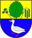
Blazon : “Divided by gold and blue. Above is a green alder leaf between a green fruit cluster on the right and a green inflorescence on the left, below a striding silver duck with a golden beak and red feet. "
The figures on the municipal coat of arms , alder and duck , both refer to the name of the municipality. The choice of the figure for the upper half of the coat of arms is based on the Low German (Eller, Ellerboom) and Danish (el, elle) form of denomination of the alder, while the lower half takes that proposed by Pastor J. R. F. Augustiny from Hollingstedt in his chronicle of the parish of Hollingstedt in 1852 Derivation of the place name from "Elling" or "Alling" as a Danish name for little duck. According to the chronicler's news, wild ducks were very widespread as breeding birds on the Rheider Au, which touched the municipality . The alder is still the typical tree species for the municipality today, which is not only frequently found in the lowland area of the Rheider Au, but has recently also been widely used as a crook .
economy
The municipality is predominantly agricultural.
societies
In addition to a volunteer fire brigade and the sports club, Ellingstedt also has a rifle guild, a women's choir, a theater group and the "Ellingstedt-then" working group. The German Red Cross (DRK) is also actively represented in town.
Web links
http://ellingstedt-damals.jimdo.com/ Documents, reports and pictures from Ellingstedt's past
Individual evidence
- ↑ North Statistics Office - Population of the municipalities in Schleswig-Holstein 4th quarter 2019 (XLSX file) (update based on the 2011 census) ( help on this ).
- ↑ Erwin Mauderer: Records from the parish Hollingstedt up to the year 1890. Ellingstedt working group at that time, accessed on July 30, 2019 .
- ↑ Johannes Kok: Det danske folkesprog i Sønderjylland , 2nd volume, København 1867, p. 120
- ↑ Wolfgang Laur: Historisches Ortsnamelexikon von Schleswig-Holstein , 2nd edition, Neumünster 1992, p. 235
- ↑ That's on the way! - A rich Viking Age settlement between Hollingstedt and Haithabu ( memento of the original from October 26, 2014 in the Internet Archive ) Info: The archive link has been inserted automatically and has not yet been checked. Please check the original and archive link according to the instructions and then remove this notice.
- ↑ Conservationists save Viking site , shz.de from June 2, 2014
- ↑ Allocation of seats after local elections in 2013
- ↑ Schleswig-Holstein's municipal coat of arms
- ↑ Ellingstedt-at that time. Working group "Ellingstedt-then", accessed on July 30, 2019 (German).


