Sterup
| coat of arms | Germany map | |
|---|---|---|

|
Coordinates: 54 ° 44 ' N , 9 ° 44' E |
|
| Basic data | ||
| State : | Schleswig-Holstein | |
| Circle : | Schleswig-Flensburg | |
| Office : | Geltinger Bay | |
| Height : | 39 m above sea level NHN | |
| Area : | 17.14 km 2 | |
| Residents: | 1332 (Dec. 31, 2019) | |
| Population density : | 78 inhabitants per km 2 | |
| Postal code : | 24996 | |
| Area code : | 04637 | |
| License plate : | SL | |
| Community key : | 01 0 59 167 | |
| LOCODE : | DE 72Q | |
| Office administration address: | Holmlück 2 24972 Steinbergkirche |
|
| Website : | ||
| Mayor : | Sandra Hansen (Sterup Voting Association) | |
| Location of the municipality of Sterup in the Schleswig-Flensburg district | ||
Sterup is a municipality in the fishing region in the Schleswig-Flensburg district in Schleswig-Holstein .
Geography and traffic
Sterup is located about 21 kilometers southeast of Flensburg near the federal highway 199 to Kappeln on the state road 21 from Flensburg to Kappeln. The municipal area includes the district Grünholz (Danish: Grønholt ) with Grünholz-Husum ( Grønholthusum ) and the residential areas Barredamm ( Barredam ), Birristoft ( Berristoft or Berritstoft ), Boltoft, Borreweg ( Borrevej ), Bremholm, Brunsbüll ( Brunsbøl ), Dingholz ( Tingsholz) ), Duisberg ( Dysbjerg or Dyssebjerg ) Höckeberg ( Høgebjerg ), Jordan ( Jordam or Hjortdam ), Kalle Watt ( Kalvevad ) Laßholz ( Lasholt ) Niehuus, Osterholm ( Østerholm ) Quegmai ( Kvægmaj or Kvægmade ) Rackbüll ( Ragebol ) , Schadelund ( Skadelund , also Skardelund ), Schnabe ( Snabe , also Snave ), Solberg ( Solbjerg ), Sterupbek ( Sterupbæk ) and Sterupgaard.
history
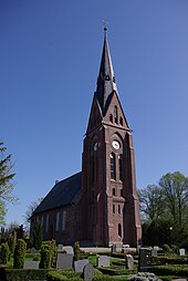
The late Romanesque St. Laurentius Church was built in 1230. The place name is first documented in 1352 as Stedorp . 1538 the form Stederup is found . There are several interpretations of the meaning. The name could be derived from dan. stæth (≈ anvil in a figurative meaning), Danish. stæthi (≈ on the bank, here on the bank of the Lippingau) or too old Danish. derive stæthi (≈ mare).
Before the German-German In 1864, as the capital of the parish of the same name, the place belonged administratively to Nieharde ( Ny Herred ) in the Flensburg office , Duchy of Schleswig . In 1983, the Sterup Township and the Royal Navy became partners . As part of this partnership, the community was visited by representatives of the British Navy during Kiel Week . These mutual visits took place until the beginning of 2000.
Incorporations
On March 24, 1974, the then community of Grünholz was incorporated.
politics
Community representation
Of the 13 seats in the municipal council, the Sterup voter community has had seven seats and the CDU six seats since May 6, 2018.
mayor
Mayor of the municipality is Sandra Hansen from the Sterup voter community.
coat of arms
Blazon : “In green a slanting left silver wave bar. The black Steruper Allmanns-Schleef in the golden base of the shield. "
economy
There are several craft, service and retail businesses in Sterup. In 1924 Otto Henningsen sen. his workshop with gas station in Flensburger Strasse. It is considered the oldest gas station in Germany.
Attractions
The list of cultural monuments in Sterup includes the cultural monuments entered in the list of monuments of Schleswig-Holstein.
literature
- Chronicle of the parish of Sterup (ed.): Chronicle of the parish of Sterup. Husum Druck- und Verlagsgesellschaft, Husum 1993, ISBN 978-3-88042-664-1
- Verein Kirchspielchronik Sterup (Hrsg.): Chronicle of the parish Sterup. Volume 2. House part Husum Druck- und Verlagsgesellschaft, Husum 2006, ISBN 978-3-89876-295-3
Web links
Individual evidence
- ↑ North Statistics Office - Population of the municipalities in Schleswig-Holstein 4th quarter 2019 (XLSX file) (update based on the 2011 census) ( help on this ).
- ↑ Originally the way to the city of Flensburg, in which the castle ( jut. Borre ), probably the Duburg, was, cf. Berthold Hamer: Topography of the landscape fishing , Vol. 1, Husum 1994, p. 113
- ↑ Johannes Kok: Det danske folkesprog i Sønderjylland , Vol. 2, København 1867, p. 115
- ↑ originally Hjortdam, from the Danish for deer pond, later as a nickname for a jug after the biblical river Jordan , cf. Berthold Hamer: Topography of the landscape fishing , Vol. 1, Husum 1994, p. 363
- ↑ Anders Bjerrum, Kristian Hald and Peter Jørgensen: Sydslesvigs stednavne , Vol. 7, Akademisk forlag 1948, p. 351
- ^ M. Mørk Hansen: Kirkelig Statistics on Slesvig Stift: Med historiske og topografiske bemærkninger , Kjøbenhavn 1864, p. 278
- ↑ Johannes Kok: Det danske folkesprog i Sønderjylland , Volume 2, Copenhagen 1867, p. 343
- ↑ Anders Bjerrum, Kristian Hald, Peter Jørgensen: Sydslesvigs stednavne , Vol. 7, Ed. 2, 1979, p. 366
- ↑ General Staff Kort over Slesvigs Fastland og Als, Kjøbenhavn 1858
- ↑ Berthold Hamer: Topographie der Landschaft fishing , Vol. 2, Husum 1995, p. 304
- ^ Federal Statistical Office (ed.): Historical municipality directory for the Federal Republic of Germany. Name, border and key number changes in municipalities, counties and administrative districts from May 27, 1970 to December 31, 1982 . W. Kohlhammer GmbH, Stuttgart / Mainz 1983, ISBN 3-17-003263-1 , p. 182 .
- ↑ Schleswig-Holstein's municipal coat of arms
- ↑ Matthias Jürgensen: The oldest gas station in Germany is in Sterup - A conversation with Otto Henningsen , in YEARBOOK of the Heimatverein der Landschaft ANGELN, 83rd year 2019/20, Sörup 2019, p. 176ff
- ↑ taz archive: Home visit in Sterup November 14, 2015 accessed on December 23, 2019


