Böxlund
| coat of arms | Germany map | |
|---|---|---|

|
Coordinates: 54 ° 50 ' N , 9 ° 11' E |
|
| Basic data | ||
| State : | Schleswig-Holstein | |
| Circle : | Schleswig-Flensburg | |
| Office : | Schafflund | |
| Height : | 32 m above sea level NHN | |
| Area : | 4.4 km 2 | |
| Residents: | 101 (Dec. 31, 2019) | |
| Population density : | 23 inhabitants per km 2 | |
| Postal code : | 24994 | |
| Area code : | 04605 | |
| License plate : | SL | |
| Community key : | 01 0 59 105 | |
| LOCODE : | DE B72 | |
| Office administration address: | Tannenweg 1 24980 Schafflund |
|
| Website : | ||
| Mayor : | Walter Stengel (WGB) | |
| Location of the municipality of Böxlund in the Schleswig-Flensburg district | ||
Böxlund ( Danish : Bøgslund ) is a municipality in the Schleswig-Flensburg district in Schleswig-Holstein . With just under 100 inhabitants, Böxlund is the municipality with the fewest inhabitants in the district.
history
Archaeological finds show that the municipality was settled in the Neolithic Age .
Böxlund was first mentioned in 1584. The place name is derived from the Danish Bögslunj ( beech grove ).
A (presumably) warm period palaeo soil was found on Stolzberg , which was formed before the Eem warm period and is therefore over 150,000 years old. Today the location is a natural monument. The fossil podzol is seen as evidence of a warm phase during the Saale Ice Age.
politics
Community representation
Since the local elections in 2008, the WGB voter community has held all seven seats in the local council. This result was confirmed in the election on May 26, 2013.
coat of arms
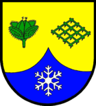
Blazon : “Divided by gold and blue by a curved half point. Above a green, opened beechnut and a green harrow placed in a corner, below a silver ice crystal. "
The opened Buchecker indicates the naming of the community. The harrow in connection with the colors green and gold stands for the agricultural character and tradition of the community. The ice crystal points to the Stolzberg, which belongs to the municipality and contains the natural monument Paläoböden on the Stolzberg . Fortunately, a land surface from a time of more than 50,000 years has been preserved here in a former gravel pit. In its completeness, this geoscientific rarity is unique in northern Germany.
economy
The community is dominated by agriculture, with pasture farming and grain cultivation predominating. Many commuters who work in Flensburg or Harrislee also live in Böxlund .
See also
Web links
Individual evidence
- ↑ North Statistics Office - Population of the municipalities in Schleswig-Holstein 4th quarter 2019 (XLSX file) (update based on the 2011 census) ( help on this ).
- ↑ E. Kopp & P. Woldstedt: About the character of the warm time between Drenthe and Warthe Stadial in northern Germany . Eiszeitalter & Gegenwart 16, 1965, pp. 37–46 Archived copy ( memento of the original from March 5, 2016 in the Internet Archive ) Info: The archive link was inserted automatically and has not yet been checked. Please check the original and archive link according to the instructions and then remove this notice.
- ^ Minutes of the determination of the election result. (PDF; 24 KB) In: amt-schafflund.de. Amt Schafflund, May 29, 2013, accessed July 30, 2013 .
- ↑ Schleswig-Holstein's municipal coat of arms


