Dannewerk
| coat of arms | Germany map | |
|---|---|---|

|
Coordinates: 54 ° 29 ′ N , 9 ° 30 ′ E |
|
| Basic data | ||
| State : | Schleswig-Holstein | |
| Circle : | Schleswig-Flensburg | |
| Office : | Haddeby | |
| Height : | 24 m above sea level NHN | |
| Area : | 16.65 km 2 | |
| Residents: | 1140 (Dec. 31, 2019) | |
| Population density : | 68 inhabitants per km 2 | |
| Postal code : | 24867 | |
| Area code : | 04621 | |
| License plate : | SL | |
| Community key : | 01 0 59 019 | |
| LOCODE : | DE DWK | |
| Office administration address: | Rendsburger Strasse 54c 24866 Busdorf |
|
| Website : | ||
| Mayoress : | Anke Gosch (nuclear power plant) | |
| Location of the community of Dannewerk in the Schleswig-Flensburg district | ||
Dannewerk ( Danish : Dannevirke ) is a municipality in the Schleswig-Flensburg district in Schleswig-Holstein . The community takes its name from the nearby Danewerk , a medieval Danish border fortification. The municipality was originally settled by the Vikings. The municipality includes Groß-Dannewerk, Klein-Dannewerk and Kurburg ( Kurborg ).
politics
Community representation
Of the 13 seats in the municipal council, the AKW community of voters has four seats since the 2013 local elections, the AAW three seats and the CDU , SSW and SPD each have two seats.
coat of arms
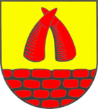
Blazon : "In gold over a growing red brick wall, two upright red ox horns facing each other, the tips of which cross each other."
Economy and Infrastructure
The municipality is predominantly agricultural.
Attractions
Thyraburg
Of the Thyraburg, the fortification at the eastern end of the Danewerk , not much has survived apart from the area. It is named after Thyra Danebod , the mother of Harald Blauzahn , although the Danewerk was created before her time. The castle probably dates from the 13th century. The Thyraburg is the only one of the three castles of the Danewerk whose location can be recognized from the topography.
Danevirke Museum
In the Danewerkmuseum (officially: Danevirke Museum ) the history of the Danewerk, which was built between the 7th and 11th centuries, is presented in German and Danish. The Danewerk is one of the largest archaeological monuments in Northern Europe. Remnants of the Danewerk can be viewed in the outdoor area. The museum was founded in 1990 and is located in a former farmhouse on the old Heerweg, the Ochsenweg .
Part of the Danewerk is the Waldemars wall, an old brick wall from the 12th century, which was built at the instigation of King Waldemar I to strengthen the wall. It is considered to be the oldest brick building in Northern Europe. Remains of the originally 3.7 kilometers long, 7 meters high and 2 meters wide wall, which was preceded by a 2.5 meters deep and 15 meters wide trench, are preserved in the municipality.
The Danewerk has been a World Heritage Site since June 30, 2018.
Web links
- Dannewerk community at Haddeby Office
- www.dannewerk.de - Private website about Dannewerk
- www.dannewerk.com - Private website about Dannewerk
Individual evidence
- ↑ North Statistics Office - Population of the municipalities in Schleswig-Holstein 4th quarter 2019 (XLSX file) (update based on the 2011 census) ( help on this ).
- ↑ Schleswig-Holstein topography. Vol. 2: Boren - Ellerau . 1st edition Flying-Kiwi-Verl. Junge, Flensburg 2002, ISBN 978-3-926055-68-2 , p. 253 ( dnb.de [accessed June 11, 2020]).
- ↑ Schleswig-Holstein's municipal coat of arms


