Hollingstedt (Treene)
| coat of arms | Germany map | |
|---|---|---|

|
Coordinates: 54 ° 27 ' N , 9 ° 20' E |
|
| Basic data | ||
| State : | Schleswig-Holstein | |
| Circle : | Schleswig-Flensburg | |
| Office : | Arensharde | |
| Height : | 4 m above sea level NHN | |
| Area : | 17.51 km 2 | |
| Residents: | 999 (Dec. 31, 2019) | |
| Population density : | 57 inhabitants per km 2 | |
| Postal code : | 24876 | |
| Area code : | 04627 | |
| License plate : | SL | |
| Community key : | 01 0 59 039 | |
| Office administration address: | Hauptstrasse 41 24887 Silberstedt |
|
| Website : | ||
| Mayoress : | Petra Bülow ( CDU ) | |
| Location of the community Hollingstedt in the Schleswig-Flensburg district | ||
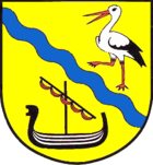
Hollingstedt ( Low German : Hornstedt , Danish : Hollingsted ) is a municipality in the Schleswig-Flensburg district in Schleswig-Holstein . The place on the Treene is known for its history in the Viking Age and the many storks : a Viking ship and a stork are part of the coat of arms. Friedrichsfeld is located in the municipality.

geography
Hollingstedt is located on the Schleswig Strait ( isthmus ) between the North Sea and the Baltic Sea . It belonged to the historical administrative unit Arensharde in the Gottorf office . Already in 1231 listed the Erdbuch of Waldemar II. The Arens Harde as an area in Istathesyssel .
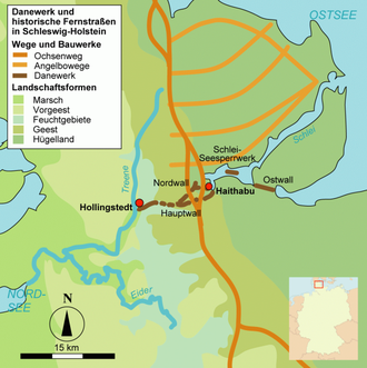
The parish adjoins the eastern bank of the middle Treene and spreads out on both sides in an easterly direction. The church village lies on an old moraine that has pushed a tongue of sand up to the Treene. This sand runoff made it possible to settle in a landscape that was almost entirely surrounded by moor , swamp and jungle. At the same time there was a connection to the east running Ochsenweg and the former Haithabu . The Stapelholmer Weg ran through Hollingstedt - coming from Oeversee from the north and ending in Süderstapel on the Eider .
A sea trade route between the North Sea and the Baltic Sea existed in the west-east direction through Hollingstedt, because only an isthmus between the Treene and the Schlei, about 15 kilometers wide, had to be crossed: Ships could get to Hollingstedt via the Eider and Treene. It was then possible to use the Rheider Au with smaller ships. Then the ships had to be pulled from the Rheider Au overland to Selker Noor in order to get into the Schlei. Alternatively, they used the Kograben just south of the Danewerk .
Around three pairs of white storks breed annually on concrete poles in the village. In the mid-1960s there were 15 to 19 breeding pairs. There is another occupied nest in Friedrichsfeld.
history
The place was mentioned in 1153 as Hugstaeth , in 1285 as Huglaestath and in 1436/62 as Hollingstedte (from the short form of the Norse Hugleikr and stedt). In the 13th century, the different names Hylingstada and Hylingstadir appear. In the same century the place is mentioned in the Knýtlinga saga . The name is of old Danish origin and is interpreted in place name research as a hill town.
In the Neolithic Age , farmers lived here around Hollingstedt. This is evidenced by the discovery of a stone ax from the Neolithic individual burial culture , a late Neolithic flint dagger and several flint tools in today's municipal area.
In 449 the anglers in Hollingstedt are said to have boarded their ships to sail across the North Sea to Britain. There is also an old map from 1596 in which Hollingstedt is named as the starting port for fishing.
During the Viking Age (800-1050 AD) Hollingstedt formed the western end point of the Danewerk , which led in an easterly direction over the entire Schleswig isthmus to Haithabu .
Ansgar , the apostle of the north, is said to have come ashore here with the Viking king Harald Klak from Mainz in 826 .
During excavations in and around Hollingstedt, thousands of fragments from the 6th to 13th centuries were found, which can testify to lively trade. Further soil investigations and excavations on the banks of the Treene - in the Lahmenstraat - revealed evidence of a medieval harbor and indications of the construction and repair of ships. A loading point for Rhenish tuff was also found during excavations on the Süderwiesenbach, which was used in the construction of many churches on the North Sea and in the Schleir region even as far as the Baltic Sea. A special monument from the 12th century is the Hollingstedter Church, which was also built from Rhenish tuff . It stands just under 100 meters from the bank of the Treene, at a point where, as excavations have shown, a house had previously stood.
In the years from 1760 to 1765 Frederick V , King of Denmark and Norway, had a bog colony built in the north-east of Hollingstedt , which was called Friedrichsfeld. At that time colonists from southern Germany were settled here in order to make the moorland arable.
Hollingstedt was used as an important trading port more than a thousand years ago. Despite the difficult overland transport of the freight, the natural shipping route was cheaper and safer than a detour through the Skagerrak . Two jetties from the 12th century were discovered during archaeological excavations, which corresponds to a use as the western port of Schleswig. The Hollingstedter Hafen was apparently approached by ships of Nordic design as well as by early cogs . Goods from the Baltic Sea region were likely to have mainly been hides, wax and honey, while wine, ceramics, weapons and later also tuff were imported from other regions.
The Treene was a tide-dependent body of water until it was dammed near Koldenbüttel in 1570: The tidal range of the North Sea reached over the Eider to Hollingstedt and thus enabled shipping when the tide came up. After this damming, water traffic was only possible with smaller ships.
The path behind the church to the parish hall also falls steeply downhill to the south. King Sven III. von Denmark visited the place when he launched ships in Hollingstedt in 1153. Since 1965, regional materials for teaching have been collected in the school building.
Another prominent guest was Tsar Peter the Great , who stayed in Hollingstedt in 1713.
Hollingstedt belonged to the Friedrichsfeld community until it was dissolved on January 20, 1873. Hollingstedt was one of the three successor communities.
politics
Community representation
Of the eleven seats in the municipal council has CDU since the municipal election 2003, six seats and the voter community AWG five.
coat of arms
Blazon : "A blue diagonal wave bar in gold, accompanied above by a striding stork in natural colors, below by a black Viking Age ship with a reefed red sail."
economy
The municipality is predominantly agricultural.
Culture
societies
In addition to a volunteer fire brigade and the sports club, there is also a country women’s club, a rifle’s guild, a church choir, a gospel choir and a hunter’s club in Hollingstedt.
Festivals
Every year in mid-August the Treenefete takes place in Hollingstedt, which has over 1000 visitors.
church
The building of the St. Nicolai Church consists of tuff that was brought to Hollingstedt from the Eifel via the Rhine , North Sea, Eider and Treene. Today the church is a bit out of the way - the remains of a Viking settlement were found during archaeological excavations.
museum
The Hollinghuus Museum presents the history of the community. The school house museum is still located in the school building itself and shows the development of a village school. The focus of the collection is a classroom from 1876.
Cultural monuments
The list of cultural monuments in Hollingstedt (Treene) includes the cultural monuments entered in the list of monuments of Schleswig-Holstein.
Personalities
Sons and daughters of the church
- Heinrich August Mau (1806–1850), Protestant theologian
- Erik Eggers (* 1968), historian, sports journalist and author
People related to the community
- Helene Nissen (* 1996), singer-songwriter of soul, blues and pop music
literature
- Klaus Brandt (Ed.): Hollingstedt an der Treene. A river port from the Viking Age and the Middle Ages for transit traffic between the North Sea and the Baltic Sea. Wachholtz, Neumünster 2012, ISBN 978-3-52901811-4 .
- Alfred Ehrhardt : Between the Schlei and the mouth of the Eider. An old world trade route of the north. Hamburgische Bücherei, Hamburg 1947.
- A. Th. Petersen: Description of the parish Hollingstedt. Edited from authentic sources. Schleswig 1890.
- Dagmar Unverhau: Hollingstedt from a cartographic-historical point of view. Wachholtz, Neumünster 1987.
Web links
- Hollingstedt municipality
- Hollingstedt - former North Sea port at sh-tourist.de
Individual evidence
- ↑ North Statistics Office - Population of the municipalities in Schleswig-Holstein 4th quarter 2019 (XLSX file) (update based on the 2011 census) ( help on this ).
- ↑ Schleswig-Holstein topography. Vol. 4: Groß Sarau - Holstenniendorf . 1st edition Flying-Kiwi-Verl. Junge, Flensburg 2004, ISBN 978-3-926055-75-0 , p. 347 ( dnb.de [accessed on May 3, 2020]).
- ^ Dagmar Unverhau: Hollingstedt from a cartographic-historical point of view. Wachholtz, Neumünster 1987, p. 113.
- ↑ Report at gubrun.de , accessed on July 10, 2016
- ^ Dagmar Unverhau: Hollingstedt from a cartographic-historical point of view. Wachholtz, Neumünster 1987, p. 85.
- ↑ State Statistical Office Schleswig-Holstein (ed.): The population of the communities in Schleswig-Holstein 1867 - 1970 . State Statistical Office Schleswig-Holstein, Kiel 1972, p. 237 .
- ↑ Schleswig-Holstein's municipal coat of arms


