
Weißbach (Wilde Weißeritz)
| Weissbach | ||
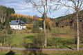
 Upper Weißbachtal (Köhlergrund) at the former Ramm-Mühle |
||
| Data | ||
| location | Saxony , Germany | |
| River system | Elbe | |
| Drain over | Wild Weißeritz → Weißeritz → Elbe → North Sea | |
| source | a little below Hermsdorf in the Ore Mountains | |
| Source height | approx. 750 m | |
| muzzle | between the Kempenmühle and Schönfeld in the Wilde Weißeritz Coordinates: 50 ° 46 '34 " N , 13 ° 38' 43" E 50 ° 46 '34 " N , 13 ° 38' 43" E
|
|
The Weißbach is a left tributary of the Wilden Weißeritz in Saxony.
course
Its source is to the south, a little below Hermsdorf in the Ore Mountains at around 750 m. The stream first flows in an easterly direction, then in a northerly direction through the Köhlergrund. At the confluence of the Hermsdorfer Bach (Richtergrund), where the Hermsdorf - Seyde road crosses the valley, the Ramm-Mühle stood until 1970. The Weißbach then reaches the lower end of Seyde (old road Hermsdorf - Seyde), here is the former vinegar mill on the left side of the valley. Then follows the lower part of the Weißbach valley. After about 4 kilometers the Weißbach flows into the Wilde Weißeritz near the former Kirstenmühle (demolished in 1971) between the Kempenmühle and Schönfeld. A hiking trail leads through the Weißbachtal, the valley is without traffic, without trade and apart from two houses (Seyde) uninhabited. Therefore, the stream is considered a valuable flowing water, the flow rate is about 80 liters per minute.
The Weißbachtal

The headwaters of the Weissbach

Former vinegar mill Seyde
Weißbachtal near Seyde

Lower Weissbach Valley


Individual evidence
- ↑ Hermsdorf in the Eastern Ore Mountains (accessed December 5, 2015)
- ↑ Geoview - Weißbach (accessed December 5, 2015)
- ↑ Weißbachtal nature guide (accessed December 5, 2015)
- ↑ Flood and nature protection in the Weißeritztal / Weißbach (accessed on December 5, 2015)