
Vistula breakthrough
| Vistula breakthrough | ||
|
|
||
| Data | ||
| River system | Vistula | |
| origin | Arm of the Vistula River 54 ° 20 ′ 57 ″ N , 18 ° 47 ′ 15 ″ E |
|
| muzzle | in the east of Gdańsk in the Gdańsk Bay Coordinates: 54 ° 22 ′ 14 ″ N , 18 ° 46 ′ 51 ″ E 54 ° 22 ′ 14 ″ N , 18 ° 46 ′ 51 ″ E |
|
| Mouth height |
0 m
|
|
| length | 2.5 km | |
The Vistula Gorge ( Wisła Śmiała in Polish ) is a 2.5 km long estuary of the Vistula in the Gdańsk Bay near the city of Gdańsk in Poland .
The Vistula Gorge separates the islands of Wyspa Portowa in the west and Wyspa Sobieszewska in the east. The bird paradise nature reserve ( Rezerwat Ptasi Raj ) is located on the east bank and the Green Islands nature reserve ( Zielone Wyspy ) to the west . The Vistula shipyard and the sailing center Narodowe Centrum Żeglarstwa are located at the northern end of the Vistula Gorge .
history
The arm was created on the night of February 1 and 2, 1840, when the narrow and low dune 300 meters in length gave way to the pressure of the ice jam and the river found a new outlet into the Baltic Sea. The village of Neufähr was divided into two parts: East of Neufähr (today: Górki Wschodnie ) and West of Neufähr (Górki Zachodnie) . The new estuary was called the Vistula Gorge. Wincenty Pol gave the Vistula the name "Wisła Śmiała" (translated bold Vistula ).

The Vistula Gorge
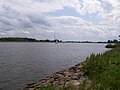
View from east of Neufähr to the Vistula

Vistula Gorge on the 1901 map


.JPG)

See also
Individual evidence
- ↑ a b Wisła Śmiała in the Encyclopedia WIEM. Retrieved July 20, 2020 (Polish)